For interested readers I have just published a new book entitled
Two Years Behind the Plow; Bringing the Green Revolution to Nepal.
It describes a small group of Peace Corps volunteers's efforts to engage Nepali farmers in the Green Revolution. Between 1969 and 1971 I lived in a small village in a remote jungle valley at the foot of the Himalayas. With mixed success I demonstrated the advantages of using hybrid seed and chemicals to increase the productivity of local rice, maize, and wheat crops. Interspersed with humorouns tales of my experiences, I describe the physical and emotional challenges faced by young American Peace Corps volunteeers living in a dramatically different culture. For those keen to understand Nepal today, I share the highlights of living there half a century ago.
If you wish to order a copy of this 254 page book it costs $20 including postage. You can contact me at raincloudtreefarm@yahoo.com to place an order
Wednesday, August 7, 2019
Saturday, November 7, 2015
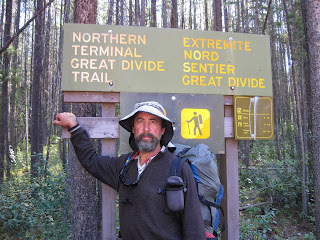
The Great Divide Trail
In 2014 I published Walking Away from the Land that focused on my hike of the American Rockies and the impacts of climate change on the land. Initially, as part of that book, I proposed including my hike of the Great Divide Trail as well, but because of the length of the book, decided against it,
For those readers who did read Walking Away from the Land, and still might be interested in hearing a bit more of my adventures in the Rockies (with a few repetitious stories) here there are:


For those readers who did read Walking Away from the Land, and still might be interested in hearing a bit more of my adventures in the Rockies (with a few repetitious stories) here there are:
Part II: The Great Divide Trail
Tracing the Crest of the
Rocky Mountains: A Convoluted Journey
·
August 4 to September 13, 2009, Waterton
Township to Jasper, Alberta

The Molars, Banff National Park
After spending a few days at a campground in Glacier
National Park and sharing its wonders, my friends drop me off at the
Backpacker’s Inn in East Glacier. This two
room bunkhouse set in a lawn behind the ever popular Mexican restaurant is
where I started my hike of the Continental Divide Trail three years ago. A day later my resupply packages for the
Great Divide Trail to arrive from home.
I reserve a seat in the Red Grinder, Glacier Park’s
concessionaire operated tour bus, from the front porch of East Glacier Lodge
across the border to Waterton National Park.
I discover riding in the back seat of the 1930’s era renovated propane
powered open topped touring car an easy way to smuggle goods into Canada. The Canadian border guard, accustomed to
seeing this daily tour bus filled with wealthy senior citizens regularly
crossing the border, simply counts our passports and heads before waving us
through. As we pull away the guard’s
mouth drops open when he sees me huddled in the backseat buried in a pile of
heavily taped cardboard boxes.
I leave my pack at the Waterton Visitor Center and
struggle down the hill and into the heart of town carrying two heavy unwieldy
oversize boxes. I feel like an African
porter carrying them precariously balanced atop my head. The post mistress is happy to stash the boxes
in a corner. I call each of my proposed resupply points to
guarantee that they will accept my incoming resupply packages. This takes an hour and often involves
speaking to multiple levels of bureaucracy, but I return with a big smile and
list of valid addresses that I transfer to five smaller bundles I neatly
packaged over a month ago inside two larger boxes. Not only does it cost considerably less to
mail these packages inside Canada, but I do not have to deal with customs declarations. Exotic food items like Swiss chocolate and
Indian rice can hold these boxes at the border indefinitely.
Canada and the US custom authorities love to play tit for
tat border games. Even though meat
tainted with mad cow disease was found in beef raised in the United States, US
customs officials confiscate all red meat produced in Canada at the
border. And once US officials decided
that anyone with a Canadian drunk driving offence cannot cross the border,
Canadian officials did the same for all US drivers with a similar offence. The terrorists have won. A friendly wave thru like the one I
experienced today is a forgotten courtesy at most America’s borders since 9-11.
CHAPTER
XVI
Canadian Hinterlands

Waterton-Glacier International Peace
Park
After
mailing out my resupply packages, I return to the Waterton Visitor Center to
purchase my required park permits. They are costly, totaling several hundred
dollars. The Canadian Park agency, Parks Canada, follows a more regimented
European system of backcountry management. Like the United States, they require
an annual user fee to repeatedly enter and leave parks, but they also require
an additional backcountry fee to cover the cost of emergency services.
In
contrast, the US National Park Service attempts to recoup rescue expenses after
the fact and ends up with over five million dollars each year in unreimbursed
expenses—for which the US taxpayer foots the bill. In 2012, National Park
Service search-and-rescue teams put in over 92,732 hours on 2,876 missions
helping get people out of trouble. Most were day hikers, and most were young
men ages twenty to twenty-nine who overestimated their skill and fitness
levels. In 2012, 85 percent of the people needing help were rescued within
twenty-four hours of the first report, but twenty-six left their national park
in a body bag. I am glad that I am not a day hiker in that age group!
Add
on a nightly camping fee at designated campsites, each of which must be reserved
ahead of time in each national and provincial park I plan to cross, and the
logistics of hiking the Great Divide Trail become tricky. Fortunately, I will
be camping for a few days only in Waterton Lake National Park before entering
Crown lands managed by the Alberta provincial government, so at this point, I
need to reserve only three campsites. It is the beginning of August. The
wardens warn me I may find it more challenging to reserve backcountry campsites
during the peak of tourist season later in the month when I reach Banff and
Jasper.
For
the next four days, I also reserve campsites in Glacier National Park. In 1932,
the United States and Canada joined together to create the world’s first
international peace park: Waterton-Glacier International Peace Park. My plan is
to follow a stretch of the CDT along the Highline Trail that I missed when
beginning my trek at the Chief Mountain border crossing three years ago.
By
the time I finish obtaining all my required permits, the afternoon shuttle has
returned to the United States without me. This tosses my proposed schedule into
total disarray. I had planned to catch the Red Grinder back across the border
to St. Mary’s where I would stay overnight in the campground on the eastern
edge of Glacier National Park. I then planned to catch the next morning’s
shuttle bus up the Going-to-the-Sun Highway to start my northbound trek from
Logan Pass back toward the Canadian border.
The
weather forecast is more disturbing. Heavy rain will start falling tonight and
last for the next three days. Snow is predicted in the mountains. I pick up my
pack and trudge to the campground at the southern edge of Waterton Township. It
starts raining as I set up my tiny tent. My tent is easy to overlook in the
large municipal campground filled with giant motor homes.
To
entertain myself, I slip on my rain parka. I wander down the paved streets of
this lakeside campground, admiring this heady display of luxurious behemoths. I
chuckle at their brand names. From experience, I know that the last thing these
oversize vehicles would do is pick up a hitchhiker, yet they are proud to
flaunt their backcountry courage with words like Brave, Wildwood, Challenger,
Eagle, and Frontier. Names like Cameo, Provost, Sunnybrook, Dutch Star, and
Mobile Suites appeal to those who take pride in their comforts. Geography is
well represented within the Tahoe, the Montana, and even the Everest although I
cannot fathom how that monstrosity would ever get near its namesake. The
Dolphin, Airstream, Tradewind, and Starcraft speak to the dreamy sea voyagers
among my fellow campers. Wind reinforces the rain. Waves pounding the lakeshore
remind me it is time to return to my campsite.
Heavy
gusts of wind push in black storm clouds that release a deluge. I huddle alone
in a windswept picnic shelter, feeding my stove with torn-up pieces of dry
cardboard rescued from a trashcan to
cook my supper. At dawn, I pack up my sodden gear and walk into the village
past my comfortable camping companions. I stumble down the street with my
rain-heavy pack while they comfortably sip steaming cups of tea behind the
foggy windows of their motor homes. I follow their example by retreating to a
warm, dry coffee shop for breakfast. The weather forecast in the local paper
for the next few days is dismal.
I
scratch off my proposed hike of the Highline Trail through Glacier and search
out a local motel. Lodging in this tourist township is not cheap and is often
reserved months in advance during the summer season. I feel lucky to find a bed
at the Bear Mountain Motel. The owner tells me that I am fortunate to be here
in the middle of the week; he has a room with a tiny kitchenette available, but
only for the next two nights. As he hands me the key, he leans over and
switches on the No Vacancy sign.
I
wander around town, enjoying the English flair of carrying umbrellas taken up
by locals and visitors alike as we scuttle from shop to shop over the next two
dreary, rain-sodden days. The food choices are delightful. A bookstore and
movie theater are available, so there is no lack of entertainment. Waterton
Township’s tree-lined streets and sidewalks remind me of a tidy English
village. They are a stark contrast to the dirt roads and trailer houses of East
Glacier, only an hour’s drive away, which feels like the Wild West.
On
Friday morning, after a night of heavy rain, I awake to silence. I open the
curtain: spotlights of sunshine illuminate snow-covered peaks high overhead.
Swirling clouds slowly surrender to brazen blue sky as I eat a breakfast of
granola and powdered milk spiced with hot chocolate purloined from the motel
office. I take one last long hot shower and walk up the hill to the Waterton
Visitor Center. I obtain a camping permit for Lone Lake for tomorrow evening,
return to the motel, pack my gear, check out, and walk a few blocks in the
opposite direction to a trailhead at a waterfall hidden behind the RV park.

The Carthew Summit and Beyond
I
climb a gentle trail through dense fir and spruce forests in a narrow canyon
flanked by vertical black stone walls. Clouds swirl overhead. By lunchtime, I
reach timberline. I put on my rain gear, expecting a deluge. For the next three
hours, I clamber up through water-laden clouds past three brilliant stair-step
lakes joined by tumbling waterfalls. Marmots scramble underfoot, and ptarmigans
strut atop boulders in waterlogged meadows filled with purple lupine.
Snowfields, melted safely back from the trail, line the red rock cirques,
hinting of similar stone mesas hundreds of miles to the south in New Mexico. I
top out at the pass as a fresh wind sweeps the clouds away from the surrounding
peaks, allowing views south along the crest of the snow-brushed Rockies into
the heart of Glacier National Park, eastward out onto the golden sward of the
Great Plains, and westward across a forested sea of mountains toward the
Pacific. To the north, my future lies shrouded in vertical stone walls and
swirling clouds.
I
join four day hikers to descend five miles over 7,500 vertical feet through a
series of floral alpine meadows to Cameron Lake, where a trailhead parking lot
awaits us. From there, a paved highway follows a densely forested glacial
valley to loop circuitously back down to Waterton Township. The stone headwall
of a high cirque marks the US-Canadian border. It is reflected in Cameron Lake,
a shimmering mile-long expanse of cold, clear blue water. The lake’s northern
shore is lined with a tidy, neatly mowed lawn, a boat dock, and
concessionaire-run store. We reward ourselves with an ice cream sandwich and
say goodbye as the concessionaire locks his store for the evening. When my
companions’ cars depart, I am left alone to wander down the Akamina Parkway,
following the empty highway behind them. I follow Cameron Creek through this
densely forested valley in search of my preassigned backcountry campsite. It is
two miles up a side trail, but I can’t find the trail sign marking its entrance
in the dark.
Instead,
I find a small winter cross-country ski shelter a hundred feet from the
highway. It is surrounded by piles of picnic trash. I set up my tent in the
forest another hundred feet away in the center of a dense thicket and start
preparing dinner. I hear a crash. I turn on my headlamp. It illuminates a black
bear nosing through the picnickers’ garbage. I yell out. The bear looks up.
Startled and blinded by the light, he ambles off, carrying a shredded potato
chip bag in his mouth. I hang my food bag high in a tree as the first stars I
have seen for three nights glitter overhead.
At
dawn, I hear another crash and groggily peer from my tent. A hundred feet away,
I see a pickup truck and two wardens scrubbing out an outhouse. Knowing I am
camping illegally, I quietly remove my brilliant orange food sack from the top
of the tree and carefully fold up my green backpacking tent. They fail to
notice me and are gone by the time I step out onto the road. The outhouse is
clean, but the surrounding parking lot and ski shelter are still littered with
trash.
I
eat breakfast on a picnic table, near the shelter before hiking two miles down
the highway to the Tamarack Trailhead. Half a dozen cars fill the parking lot.
I strike out up a narrow canyon. It is noon by the time I reach a broad alpine
meadow below a steep cirque wall. It towers a thousand feet above me. I pause
for lunch before continuing my climb to Lineham Ridge pass. Laden with five
days of food, I am easily passed by the many day hikers scrambling up the trail
to this scenic vista point. It is a glorious summer day. The day hikers have
deserted the pass by the time I arrive, jogging past me as they return to their
cars and a short drive to the comforts of Waterton Township. Atop Lineham
Ridge, I am surrounded by glorious alpine scenery with remote lakes, vertical
cirques, and long talus-flanked ridges sprawling like gigantic stone octopi in
all directions. I continue onward, tracing a narrow, steep little-used trail on
the opposite side of the ridge leading into Blakston Creek Valley. The trail
quickly degrades into a brushy, overgrown roller coaster that bounces up and down
through dense forests and bogs as it winds northward along the western flanks
of the steep glacial valley.

Moose and Carving Knives
From
a safe distance, I pause to photograph a cow moose and her calf standing in a
mosquito-plagued bog. Often considered more dangerous than a grizzly bear, a
cow moose will often charge an unwary hiker without warning, using her hooves
and teeth to defend her calf. I first saw moose decades ago when I visited my
friend John in the Canadian Chilcotin. The
Chilcotin is a wide, high plateau stretching over a hundred miles eastward from
the Coast Mountains of British Columbia to the Fraser River. I first visited it
in the 1970s when the back-to-the-land movement was in full swing. Many
American expats had moved to Canada and were resettling marginal ranches and
farms skirting the massive Gang Ranch, Canada’s largest. My friend John, who
helped me build my first log cabin on the tree farm, had purchased a trap line
in the Kleena Kleene Valley and asked me to explore it with him. It took me
three long days’ travel by bus to wend my way a of couple hundred miles north
of the border to the logging town of Williams Lake and then another two hundred
fifty miles west across the plateau to a bulldozed track leading into the
valley.
There were three couples in
their mid twenties trying to resettle the valley: the first a young couple with
two young children living in a log ranch cabin five miles in, the second couple
living with a baby and a milk goat in a plastic lean-to ten miles in, and yet
the third couple with another baby living in a gigli hole, or sunken earthen
lodge, twenty miles in. As the jeep track gave way to a pack trail, we worked
our way around the thunderous rapids of the river, carrying packs on our backs
and a canoe on our heads. We paused to camp with each young family along the
way. Their skills varied greatly, but each couple was doing their best to carve
out a new life for themselves in the Canadian wilds.
The first couple, Mike and
Penny, had moved into the Kleena Kleene Valley after spending two years in the
Peace Corps in South America. They lived in a decaying log home built by a
homesteader in the 1930s. With a barn for their milk cow and horses, a chicken
coop, and a two-room log cabin with wood cooking and heating stoves, running
springwater, an outhouse, and propane lanterns, they were living comfortably in
the nineteenth century. The third couple, Peter and Ginger, who had given birth
to their son in the gigli hole the previous winter, were living at the opposite
extreme, sprawled out beneath a brush lean-to on a sandy bench above the river.
They were cheerfully echoing the lifestyle of the eighteenth-century first
peoples, with a bit of fishing tackle, a rifle, and a chainsaw to make their
lives a bit more comfortable.
But it was the second couple,
Wayne and Marty, an actor and seamstress escapees from Oregon’s Shakespearean
Festival, of whom this moose reminds me. They were living in a swale beside a
small creek, camped beneath plastic tarps braced with a bewildering array of
log timbers that they called a geodesic dome. The crisscrossed logs and
flapping tarps looked more like a twentieth-century homeless camp. I remember
squatting beside their campfire in the middle of their contraption, cooking
breakfast as the sun crept over the pine thickets to the east. A dozen pancakes
were sizzling atop the steel plate propped atop three stones on the edge of the
fire. Suddenly, their scrawny milk goat leaned over my shoulder, plucking a
steaming pancake from the grill.
Technologically, they were the poorest trained
of three couples, not even knowing how to properly repair, let alone sharpen,
that mainstay of the late-twentieth-century woodsman, their gasoline-powered
chainsaw. When we arrived, they were cutting their firewood with an axe because
Wayne said their chainsaw would not cut wood. We discovered he had put the saw
chain on backward. After we reversed the chain, he attempted to cut a log in
half, but buried the tip of the bar in gravel, dulling the saw chain, and
making his power saw as useless as before. John and I spent a couple of days
with them, carefully teaching Wayne how to care for and sharpen his chain while
hewing foot-wide planks from a nearby log that they could use to floor their
smoky geodesic dome. They were besotted with our technological prowess and
stuffed us with pancakes, morning, noon, and night. We learned to spread our
elbows to keep the goat at bay.
But back to the moose. The
locals thought Wayne, Marty, and their baby would be the first to abandon their
quest when winter arrived. Wayne was the butt of local jokes for he was a bit
of a grasshopper; it was easy to see that he was not stashing away enough
firewood, let alone food, for the upcoming seven or more months of heavy snow
and freezing weather. While his neighbors dried fish, put up hay, and canned
vegetables, he toyed with his dome. The local tradition was to hunt and kill a
moose late each fall once freezing weather set in.
This is no longer possible.
Forty years of logging has chopped up the Chilcotin’s forests, destroying prime
moose habit and allowed overhunting by a booming population of First People.
Toss in massive die-offs of beetle-killed pine, and the Chilcotin’s moose
population has collapsed. But forty years ago, it was still quite healthy. The
farther north you move in North America, the larger the moose; this cow is a
third again as large as those I saw on trails in southern Colorado. A bull
moose can weigh up to fifteen hundred pounds and can easily provide a family
with enough meat to survive the winter.
As the temperatures plummeted
and his neighbors shot and butchered their winter moose, Wayne’s tarp-covered
dome collapsed under the weight of the snow. Soon he, his shivering family, and
the goat were huddled in a tiny tattered tarp shelter. They found it
challenging to keep a small fire blazing at its entrance. By Christmas, they
were running out of food, which consisted of little more than beans and
pancakes. Wayne was forced to put on his snowshoes, heft an empty pack, and
head for the road fifteen miles up the snow-filled valley. The snow was deep
and soft. A mile or so from his camp, he came across a bull moose floundering
in the deep snow. Wayne was a large man and hungry. He was not carrying his
rifle, having left it at his camp to protect his wife and baby, but he was
packing his family’s kitchen carving knife. Wayne chased the floundering moose
into even deeper snow, leapt on its back, and cut its throat. A bull moose, the
largest of the deer family, is a massive animal, incredibly strong and, with
its palmate antlers sharpened by a long season of fighting for mates, is
nothing to be tackled with a knife. Wayne became a living legend in the
Chilcotin, and nobody ever questioned his skills again.
Wayne, his wife, and child,
like their neighbors in the Kleena Kleene Valley, struggled through that winter
and a few more. But the unrelenting hard work of survival and the siren song of
civilization eventually lured them back to homes in the cities they had
abandoned in their youthful quest to carve a life from the wilderness. They too
had walked away from the land, leaving behind them collapsing cabins like the
hundreds I saw scattered along the CDT to my south.
John allowed jackstraw logs to
pile up over the two-tracks and pack trails accessing the abandoned homesteads
in the valley. This kept out an exploding population of vehicular hunters, who
were decimating the moose population atop the Chilcotin Plateau. He exchanged
his trapping rights for hunting rights and carefully managed the local moose
population, allowing it to flourish on the fertile swamp-filled meanders of the
Kleena Kleene River. Three decades later, I helped John host wealthy Danish
doctors who flew in to hunt this hidden valley’s trophy moose and black bear.
The old homesteads, trapper cabins, and ranchlands were abandoned. But John
represented a new creative generation of entrepreneurs working hard to profit
from the natural bounty of this remote land.
I am hiking into another remote moose-filled
corner of Canada. A climb of a thousand feet brings me to the summit of a rocky
pass at the foot of Festuburt Mountain. As the clouds congregate overhead, I
stumble down to Lone Lake—an aptly named steel-gray tarn under a slate-gray
sky. I am once again alone, the lone backcountry camper on this Saturday night
in midsummer. Five campsites, two restrooms, and a system of pulleys and ropes
to hang my food sack hint that there should be more visitors, but clouds of
ubiquitous mosquitoes are my only companions as darkness closes in.
Rainsqualls
patter on the tent roof throughout the night. I arise to a damp, dreary dawn
and hike five miles through dense spruce forests to Twin Lakes where I pause
for my usual granola breakfast. Like those at Lone Lake, the campsites here too
are empty. Clearly, this week of wet weather is putting a damper on Waterton’s
backcountry use. Then I wonder if Canadians have far too much of a good thing.
Why hike this remote terrain since Canada has so much of it and far fewer
people? In contrast, eager Americans just a few miles south of here in Glacier
National Park are quite happy to wait patiently in line to reserve a crowded
backcountry campsite in similar vertiginous terrain.
Spotlights
of brilliant sunshine find just me and another—or perhaps the same?—cow moose
and her calf wading knee deep in this sparkling alpine lake, enjoying a quiet
Sunday morning baptismal. I follow a trail that winds steeply upward, climbing
two thousand feet in elevation through dense spruce and pine forests to small
summit meadows scattered along the vertical stone cliffs towering above Twin
Lakes. I leave Waterton International Peace Park through Sage Pass, crossing
the Continental Divide yet again from east to west, this time from Alberta into
British Columbia. From here on, I will be hiking on Crown lands managed by
provincial governments primarily for resource extraction.

Twining the Great Divide
My
guidebook describes the hike ahead as “extremely strenuous.” The pathfinding is
challenging since this stretch of trail, if there ever was one, has not been
maintained since it was first constructed and rapidly forgotten in the
mid-1970s. For a mile or so, I follow what appears to be a pack trail that
slowly peters out into a vague game track. A mountain goat bounds out ahead of
me as I traverse the western flanks of a high peak and slip down into a
half-mile-long slot canyon. It is lined with fifty-foot-high cliff walls that
run south-to-north atop the Continental Divide. Clambering over square-edged
boulders in the bottom of this miniature graben, it looks like the canyon
country of the American Southwest. The exception is the vision of the
spruce-forested summit of Font Peak, framed by the square slot canyon walls to
my north. These parallel stone walls,
given a few hundred million years, could be the beginning of a great rift
valley that will split the Continental Divide asunder.
I
spend the remainder of the day following a vague pack trail that loops around
the towering stone pinnacles of Font and Matik Peaks before dropping down to a
hunter’s campsite in a boggy alpine meadow beside a small spring. I prepare my
dinner, hang my food, and use a campfire’s smoke to keep the mosquitoes at bay
as the Milky Way glistens in a sparkling rainbow of russets and gold in a hazy,
smoke-clogged sky.
I
discover the real meaning of what my Canadian guidebook defines as “very
strenuous” the next morning as I continue to fight my way northward along the
spine of the continent. There is no trail, just dense brushfields and thickets
of spruce broken by small bear grass clearings. A strong westerly breeze
evolves into a thirty-five-mile-per-hour gale as the afternoon progresses. The
wind helps clear the smoky haze of distant wildfires while sailing billowy
cumulus clouds that look like racing clipper ships gathered from the distant
reaches of the Pacific Ocean straight at me. These fast-moving ships run
aground atop the stone pinnacles that I am clambering over atop the divide.
They collapse into moist tendrils of mist and disappear like the ghosts of a
bad dream. I bushwhack in five repetitive exhausting stages following the crest
of this shipwreck-laden reef a thousand feet up and then a thousand feet down
over a series of five high stone summits that crown this forested divide.
I
pause for a break from the wind in the lee of a great block of stone. Pulling
out my lunch, I sprawl in a mossy glade as the branches of slide alder rattle
against the stone like a kettle drum with each blast of wind. I am rewarded
with a calendar-clear vision of rugged snow-etched peaks marching southward
toward the border. I find it hard to believe that a generation ago, trail
builders started constructing a pathway to display this grandeur, yet ran out
of energy before reaching this long sweeping ridgeline of scenic peaks.
I
glance north and grimace. There is no hint of a trail ahead. Above me looms a
thousand-foot-high ridgeline leading to the summit of La Coulette Peak. I
cannot scramble to its summit in this gale. Its eastern wall is a series of
vertical cirques. Instead, after finishing my lunch, I opt for a traverse on
its steeply forested western flank. The distance is about a mile. In front of
me is a near-vertical slope loosely stabilized by stunted conifers, bear grass,
and loose shalelike talus. The mountainside slides out from under me with each
step. I send dozens of pillow-sized stones tumbling a thousand feet into the
forests below as I carefully clamber across a series of unstable cliffs on the
ankle-twisting traverse. I clamber onward, using one hand to tenaciously cling
to the mountain while buffeted by a steady wind blasting me with the roar of a
jet engine. Gusts slam into me while brush whips my clothing and face. An hour and
a half later, I reach a narrow forested pass on the northern flanks of the
great horned peak. Above me looms another thousand-foot climb, but it offers
the safety of a wind-sheltered, narrow, rocky ridge.
I
snack on a Clif Bar. Its powerhouse of raw sugars empowers me to tackle this
vertical scramble in one concentrated rush. My reward is a miniature spruce
forest, clipped to head height, on the opposite flank of the ridge. The
snow-shattered lower branches slow my descent to a crawl as I avoid gouged eyes,
an impaled belly, or worse. My final reward on this ridiculously strenuous
afternoon is yet another steep climb to the summit of a high mesa.
I
am greeted with a vision right out of a Hollywood movie. The scarlet plateau is
blanketed in a wind-tossed field of Indian paintbrush. I feel like Dorothy
stumbling through a field of poppies in the Land of Oz. I pause to photograph
this field of color backed by a long string of snow-etched alpine summits. As I
descend the broad, crescent-shaped mesa, gusts of wind regularly threaten to
blow me over its eastern cliffs. Vertical cirque walls drop a thousand vertical
feet to a sparkling blue glacial tarn that marks the headwaters of the forested
Castle River Valley. It stretches out in a giant U-shaped cleft between
snowcapped peaks thrusting northward. I follow a series of game trails through
meadows of wind-trimmed bear grass to an old mining road that loops up from the
valley far below. The route guide now gives me an option: either follow the
eroded remnants of this track down into the valley or continue following the
crenulated trailless Continental Divide to the Castle River Ski Area.
After
condemning the many road-weary miles I walked on the CDT, I welcome this
bulldozed escape route from this windblown, trailless divide of the GDT. I am
running short of water, and the sparkling alpine lakes glistening in the bowl
below beckon. A Rocky Mountain sheep, displaying a magnificent cornucopia atop
its head, clatters up the road’s eroded bank and sprints over the divide. The
pathway arches downward, its damp banks filled with blossoming gold-and-yellow
monkeyflowers.

Castle Creek
What
I thought was a well-graded road soon turns into a steep eroded trench, the
remains of a decade-old bulldozed seismic line. Ignoring the sparkling tarns,
this rock gulley dives straight downhill through the stunted conifer forests to
the West Fork of Castle Creek. This is the first of many seismic lines that
will ease my passage through the dense spruce and alder thickets that blanket the
steep slopes of the Canadian Rockies. The strategy is simple: bulldoze a
seismic track straight up or down a mountainside, lay out a string of
explosives, set them off, and use the seismic echoes to map the underlying
formations in hopes of finding valuable deposits of gas or oil. The three
hundred kilometers of Crown lands between Waterton and Banff are regularly
etched with these eroding trenches that, in a few thousand years, if humans
still inhabit this planet, will leave geologists scratching their heads at a
legacy of steep canyons regularly dissecting the vertical cliff walls of the
Rockies.
I
set up my tent in a rubble-strewn clearing near a mind-numbing roar of tumbling
white water. As I cook my dinner, I worryingly review the guidebook. I happily
discover that today’s bone-jarring transect may prove to be the most
challenging cross-country stretch of the GDT. None of the other sections ahead
are preceded with the red flag words “very strenuous.” Today’s brushy
roller-coaster trek was far more exhausting than anything I faced on the CDT. I
am amazed at my ability to persevere. Now I am sitting by a creek in the center
of perfect grizzly habitat; the nearby rushing river camouflages any sound or
scent, both for the bruin and for me. I carefully hang my food and sleep
fitfully with La Collette looming like the North Face of Everest in my dreams.
At
dawn, I follow a single set of fresh bear tracks down the muddy ATV road. I
slide under a locked gate and walk into a small campground. There I meet James,
a local rancher in his midfifties. He is bent over, pulling invasive weeds from
an old sawmill site. I point out the fresh bear tracks. He smiles and laughs.
“Yeah, I saw him for a second or so when I arrived. He was mucking around in
that swamp over there.” He points to a broken beaver dam. “He’s a
young’un—looked like a two-year-old griz. He probably smelt ya last night when
he wandered past your campsite and scadoottled down here looking for better
grub.”
James
has no fear of grizzlies but instead tells me they will do everything they can
to avoid encountering humans. He blames fearful young hunters, their adrenaline
spiked by too many beer-guzzling bear fantasies spread around the campfire, for
the continuing genocide of the Rocky Mountain grizzly population. “Our local
wide-eyed young hunter always pleads self-defense. They’re clearly lying when
they tell the investigating Mountie of being charged by the ferocious ol’ griz
that now lies riddled with lead at their feet. It gives them lots of bragging
rights at the local tavern and a bearskin rug to impress the girls.”
James
speaks of curious young bears like the one he scared off just before I arrived.
“They are just trying to find their way in the world. Hell, yesterday I was out
picking saskatoon berries in my backyard. I heard a noise and watched a young
cub clamber up atop the vertical culvert covering our spring box. He was less
than fifty meters away. I knew his mom was around somewhere, so I backed off to
a nearby hillside. That young’un clung to the top that old pipe, slowly turning
in circles like an overweight ballerina. His head was between his legs, staring
down into that clear pool of springwater. He circled the rim of that culvert
for twenty minutes, clearly enchanted by the little bear he saw in the black
mirror of water at the bottom of that culvert. It was staring right back up at
him.”
He
tells me of how the local Mounties collect highway-killed deer, elk, and moose
every winter, stashing the carcasses away in his family’s potato shed. In the
early spring, they help scatter the winter’s collection of road carnage around
the backcountry to provide much-needed protein when the bears awake from
hibernation. In Alberta, the grizzly population totals about seven hundred
bears and is formally listed as “threatened.” Nationally, Environment Canada
has listed the grizzly as a “special concern” species with the most recent
census showing the population in decline, especially in the heart of its
historic habitat west of the Continental Divide in British Columbia. At least
Canada and, begrudgingly, the United States are trying to address the problem.
In contrast, the Mexican grizzly bear (Ursus arctos nelsoni) is extinct.
He
points out that grizzly bears normally avoid all contact with people. In spite
of their obvious physical advantages, they rarely view humans as prey. Most
grizzly bear attacks occur when the bear has been surprised at very close
range, especially if it has a supply of food or offspring to protect. Again, as
I have heard and practiced throughout this hike, my best protection is letting
the bear be aware that I am around.
I like his reassuring talk. Clearly,
my mantra—“Hey bear, hey bear”—when hiking in brushy bear habitat has kept the
bruins at bay. We say our goodbyes. A few minutes
later, I meet a group of twenty high school students toiling up the road
carrying overloaded backpacks. They are joining James for an afternoon of weed
pulling and homespun natural history.
Ten minutes later, I pass
their yellow school bus parked next to the hostel at the Castle Mountain Ski
Resort. I notice a Coke machine on the porch, but after setting my pack down
and wandering around a dozen newly built condos, I realize the resort is empty.
My dream of finding change for a twenty-dollar bill so I can slip a loonie—the
gold-colored one-dollar Canadian coin that bears a common loon—into the Coke machine is
thwarted. I heft my pack and continue trudging down the wide gravel road.
For
the next five kilometers, every five minutes I am dusted by a pickup driven by
a cowboy-hatted zombie. Each seems to be staring straight ahead as they parade
up and down this dead-end road. They never blink an eye nor seem to notice my
friendly waves. I can’t tell where they are going or whence they are coming.
There are no homes or ranches that I can see, just an empty ski resort and a
locked gate behind me at the road’s end. I escape the midday sun by pausing for
lunch in a grove of lodgepole pine. I watch closely, waving at each pickup as
it passes. I am never passed twice by the same vehicle nor receive even a
glance of recognition, let alone a friendly wave, in return.
I
am constantly amazed at the differences between folks living in rural areas.
One long, windy winter, I lived and worked as a reporter in a small town in
central Illinois. Every driver I met on every rural road gave me a friendly
wave and a broad smile. But in this stretch of the Rocky Mountains, from
Lincoln, Montana, to the Castle River Valley, Alberta, strangers seem to be
feared and ignored.
Bemused
by this passing brigade of road zombies, I pull out my guidebook. It advises me
to find Suicide Creek, appropriately named given the local social territory. I
am to follow it, working my way back up toward the crest. A few miles farther
on, I find an ATV track running up a creek bed. It quickly ends in a deeply
eroded seismic line that jumps a thousand vertical feet straight up the
mountainside. I clamber up a fresh alluvial fan of well-washed gravel, then
over house-sized boulders lining the fifty-foot-deep erosion gulley before
scrambling breathlessly upward, seeking out a continuation of the ATV trail
atop the ridge.
A
narrow track, as the guidebook promised, is awaiting me. It is a mud wallow
lined with brushy entanglements. I dig out my compass and guidebook regularly
at every signless mud- puddle junction. I spend the remainder of the afternoon
wandering through a swampy maze of ATV tracks buried deep in a dense lodgepole
forest atop a viewless plateau. Every hour or so I step aside as a convoy of ATVs
parade past, their mud-splattered occupants grinning broadly through the
Plexiglas shields of their colorful helmets. I am discovering I have two
choices hiking the Great Divide Trail through the Canadian Rockies: either an
exhausting mountaintop scramble atop view-stuffed peaks or easy walking in
off-road-vehicle mud wallows at their base. After yesterday’s breathless
scramble around Collette Peak, this mud is fine with me.
At
dusk, gray clouds gather over the Continental Divide to the west. Quarter-sized
raindrops pelt me. I set up camp beside Lynx Creek, huddling under a wooden
bridge to cook dinner. A wet night followed by a cloud-shrouded sunrise
surprises me with a dry morning’s walk. I climb a broad gravel road through the
charred white snags of what was once a vast coniferous forest. The guidebook
leads me two thousand vertical feet up an abandoned logging road to the summit
of Willoughby Ridge. It is viewpoint displaying total devastation. Wildfires
have charred the landscape for twenty miles in every direction, stretching from
the crest of the Continental Divide to the Great Plains. My pathway is
blockaded by a two-mile long, repetitive fence line of chest-high downed
timber. I detour two thousand feet back down through wet brush on the opposite
side of the ridge to the Lynx Creek Road. It traces the contours of a canyon
far below. Then I use the road to circle Willoughby Ridge for two miles, using
the easy gradient of the road to climb seven hundred vertical feet, crossing
the summit of a minor divide between Lynx and York Creeks. These blocked trails
and erratic zigzagging detours are beginning to erode my faith in the accuracy
of my decade-old guidebook and outdated contour maps.
Coleman
Rain
clouds storming the sheer peaks of the Continental Divide to my west finally
break through after lunch. A relentless afternoon deluge chases me down the
York Creek ATV trail, transforming it into a muddy slide that delivers me to a
gravel road. It leads to the city of Coleman. I arrive, along with an even
heavier deluge, at dusk. I seek shelter in the Grand Union Hotel, a dilapidated
three-story edifice in the heart of this century-old coal-mining community.
Tossing
my sodden pack behind a glowing woodstove, I greet Glory Jo, the brown-haired,
brown-eyed, round-faced owner of the hotel. In her midforties, she has a
wonderful smile, but is a bit tipsy after an afternoon sharing drinks with her
regulars. She tells me she spent her youth as the lead singer for a band that
traipsed the length and breadth of Canada. She has returned to this, her
hometown, in hopes of “making a go at it” restoring this crumbling hotel. She
is so taken by my trail adventures that she gladly takes a break from bar to
mix together a huge cob salad and dish up a steaming bowl of cabbage soup—the
perfect combination after a long afternoon of sloshing muddy roads in wet
boots.
I
explain that I am looking for “A Safe Haven B and B,” a refuge that every GDT
hiker has listed as a “must-stop” on their websites. She volunteers to drive me
there in her Dodge van, but makes a grand detour to show me the highlights of
Crowsnest Pass. It consists of a string of tiny coal-mining communities strung
out along Pinchor Creek. They stretch from the crest of the Rockies eastward to
the Great Plains. These coal reserves, first mined in 1885 to keep the
locomotives of the transcontinental Canadian Pacific Railway running, have been
replaced by tourists migrating through town along Highway 3 and even bigger
strip mines hidden in the backcountry to the north.
Glory
Jo drives east to an enormous pile of boulders stretching out for a half mile
along the highway. They lie at the foot of a shattered mountain. This is the
Frank Slide. The crumbled rock and bare earth looks like it arrived here
yesterday, but it actually tumbled here in 1903 when the nearby mountain gave
way, burying seventy coal miners and their families under millions of tons of
rubble. Then she drives me west, crossing the green meadows and clear ponds
atop Crowsnest Pass as the setting sun illuminates the stair-step peak that
gives the pass its name. Cradled in a halo of golden clouds, the peak rises in
massive tiers of granite above an emerald blanket of spruce forests.
I
say goodbye to Glory Jo in front of a small white suburban house pressed
tightly against the busy highway. A stout sign in the front yard tells me this
three-and-a-half-star bed-and-breakfast is Perfume and Chemical Free. I am
greeted by Dan and Elaina, an incongruous couple, at the front door. Dan, a big
man dressed in a denim shirt and jeans, has long stringy gray hair, a small
gray moustache, and wire-rim glasses. He looks like an aging hippy. Elaina, a
petite woman half his size with a crisp English accent, has neatly curled
closely cropped hair and is dressed in a freshly pressed green-striped blouse.
She looks like a prim English matron. I feel like I have walked into a BBC
comedy show. I imagine that their lives must have incongruously intertwined at
a long-forgotten rock concert. They lead me to a small bedroom in the back of
their home.
They
appear very happy to see me, for it has been an unseasonably wet and slow
summer for backpacking tourists. I am only the third GDT hiker that has stayed
with them this season. Most years they have hosted an average of ten
long-distance hikers by early August. They invite me to their kitchen where I
hang my wet anorak on a chair. They cheerfully offer me a glass of beer, a bowl
of spicy hot chili, and a slice of bread fresh from the oven while sharing the
latest bits of trail gossip.
There
really isn’t much trail news. Two weeks ago, the first hikers of the season, a
northbound couple from Alaska calling themselves “the Northern Lights,” passed
through. A few days ago, a southbound hiker named Scott spent a night here. He
told Dan and Elaina that he had a discouraging time skirting the open-pit coal
mines on the western flanks of the Rockies a day’s walk north of Coleman. He
was picked up by a company patrolman, threatened with arrest, and deposited ten
miles from the trail on a dirt track far outside the mining companies’ permit
area.
Management
of Crown lands is different in Canada than public land management in the United
States. Provincial governments rarely print maps detailing improvements on
public lands. Instead, they happily surrender management and oversight to
whatever mining, petroleum, timber, or other extractive business willing to
pay, to lease the land. The lessees take control of their parcels, where they
install gates, build roads, and fence the land at their convenience. This is
done with the tacit consent of the local, provincial, and national government.
This may prove a harbinger of things to come for the US Forest Service and BLM
where “stewardship contracting” will soon change their land management
objectives.
If
so, the result for recreationalists will be disconcerting. In Canada, official
maps detailing new or existing roads, trails, or other access routes on Crown
lands are nonexistent. The contour maps I purchased for my hike are twenty
years out of date and, as I have discovered over the past few days, rarely show
recently constructed logging roads, mining tracks, or ATV trails. These
developments are not openly shared with the public since they are built and
maintained by the land’s lessees who would prefer not to have the public using
these lands. This lack of updated maps, as noted in the guidebook, makes
traversing these dense forests and this steep terrain far more challenging than
I expected.
The
next morning, after a comfortable night’s sleep, I call home and speak to my
distraught wife. She has a sprained ankle and, in tears, requests that I return
home immediately. I explain that given how challenging this trail is and with
every succeeding year counting against me, I need to complete my hike of the
Rockies sooner rather than later. I promise to pick up my pace and return home
within a few weeks. I tell Marty I love her and will be home soon. The rain is
still falling as Elaina drives me downtown to the Crowsnest visitor center.
There I discover pay dirt: a locally produced Crowsnest Pass Quad Squad ATV and
snowmobile map. It is a detailed map of the maze of backcountry logging roads
and snowmobile trails stretching fifty miles north of Crowsnest Pass. In
studying it, I quickly discover a number of shortcuts that will avoid the
coal-mining allotments west of the divide and should save me many days’
circuitous travel. My despised mechanized trail companions have turned into my
blessed benefactors.
I
follow Highway 3 westward out of Coleman under cloudy skies. I hike three miles
up the highway to turn north on Atlas Road. It is a gravel thoroughfare used by
a passing convoy of oversize log trucks hauling newly cut spruce logs from the
heart of the Rockies. Around noon, I stumble across an incongruous sight in
this industrial landscape: a three-person team is setting up a tent and a fruit
buffet in a log landing. A young man with his arm in a sling offers me a
banana. He tells me he traveled from England to join 239 other mountain bikers
in a seven-day backcountry race. Yesterday he took a tumble and broke his
collarbone. The race follows old logging roads and ATV tracks back and forth
over the crest of the Rockies. It started and will end in Fernie, a growing
tourist destination built around a popular ski resort west of Crowsnest Pass.
I
continue walking up Atlas Road to a brightly flagged road junction. Sitting
down on a log, I enjoy lunch. I cheer loudly as mud-splattered cyclists splash
through the puddle in front of me. They grin broadly and pump their
dirt-speckled arms in salute as they skid around the corner and race down the
gravel thoroughfare.
After
lunch, I meet Jean-Claude, the senior forester for the Southern Alberta Rockies
Area, and Axel, his newly hired PhD forest hydrologist. Dressed in mismatched
baseball caps and standing next to a muddy four-wheel-drive pickup, they are
inspecting a debris-clogged culvert. They speak of their challenges as timber
managers on Alberta’s Crown lands: beetle population explosions, wildfires,
mill closures, dramatic increases in ATV use, and now, heavy rain. They tell me
that they target 40 to 45 percent of the landscape for harvest activity and
they never log slopes steeper than 45 percent. The timber from this thinning
operation will travel over 150 miles to the nearest mill.
They
are considering temporarily curtailing harvest activity. The unseasonably wet
summer is causing excessive damage to their roadbeds. This road was designed
primarily for winter use because traditionally, most logging and hauling takes
place when snow covers the ground. The freezing weather and cushioning snow
help limit resource damage. The recent outbreak of beetle-killed pine and
spruce has dramatically changed their management practices; they want to
harvest as much of the timber as possible before another wave of pine beetles
blow over the Continental Divide from British Columbia and destroys its value.
Clearly these muddy roads designed for travel when frozen solid are not up to the
challenge.
Competition
has closed the local mills, leaving only one large technically efficient mill
near Calgary still in business, thus the long costly haul. Jean-Claude and Axel
are afraid that if they temporarily curtail this operation, the operator will
move his logging equipment elsewhere and they will lose their only financially
viable option to protect this forest. They spin the toes of their boots in the
ankle-deep mud, stare at the rain-sodden skies, and look responsibly morose.
They
fear that the sun will come out and that nature will solve the beetle outbreak
for them, as it has south of Crowsnest Pass. Wildfire is a wonderful, but
wasteful, restorative. I wish them the best and hike on, knowing that
conservation reflects a subtle balance between man and nature that even a PhD
in hydrology can’t easily resolve.

Backyard Forestry
For a quarter of a century,
while I worked seasonally on the Columbia Gorge Ranger District, our family
helped maintain our own small tract of forestland, commonly referred to as a
family tree farm. Not only did our
children help us clear the brush and replant the cleared land with fir, cedar,
and alder, but we also constructed a road the length of the property and
brushed out trails looping through the property, which our neighbors and their
dogs still use. We thinned the trees, using the logs to construct our new home
we called Cougar Ridge Lodge and then recycled their tops and limbs as firewood
to heat our home. Our sons, our daughter, and their friends earned money
pruning the lower branches from the fast-growing conifers in hope of making
them more valuable as knot-free sawlogs. Our family packed firewood from forest
until our hands were filled with splinters. Rewards from our local community
helped maintain our morale. We were selected as the county’s “tree farmers of
the year.” I was asked to testify before the “God Squad” to help determine the
fate of the spotted owl and joined the
Northwest Regional Practices Committee, which helps draft Oregon’s forest
regulations.
Backyard forestry is
physically demanding, whether the backbreaking labor of planting trees or
splitting cordwood. Chainsaws, a tractor, and other mechanized devices like a
log splitter made it easier (and louder), but the best moments are found in the
heady silence after a long day of work when we sat down to rest and admire what
we were creating. Our tree farm was an oversize garden, a huge latticework of
green grandeur. A few older monarchs from my grandfather’s generation still tower
two hundred feet into the air. The stiff green leaders of the young seedlings
that my family planted race upward at the rate of three feet a year,
transforming ten feet of annual rainfall and brilliant days of summer sunshine
into valuable wood fiber, needles to feed the soil, food for wildlife, and
oxygen for us to breathe. We took pride in the nurturing of the land as
ownership of the tree farm slipped farther and farther away from us.
The tree farm’s proximity to
Portland far exceeded its value as timberland. Many of the six hundred thousand
people living in our backyard were eager to pay a premium price for scenic
rural estate. That meant that our tree farm’s value increased far faster thanmy
Forest Service earnings or my wife’s salary as a teacher in the local schools.
Although we lived on the property, managed the forest, paid the taxes on the
property, and worked hard to increase its value, every increase in value was
shared three ways between its legal owners: my brother, sister, and me.
At one point, when log
prices briefly reached a lifetime apogee, we reached an agreement to buy out my
brother’s share after we harvested the most valuable stand of timber on the
property. I carefully managed the harvest, and we ended up with more money than
we had ever possessed before. Once my brother received his share of the
harvest’s profits, he reneged on the agreement and spent the next two years
attempting to hit a jackpot as a day trader. Our tax bracket temporarily
skyrocketed. My wife and I used our profits to help pay for our children’s
college education. Their subsequent success brought us far more dividends than
the landhad, but we lacked a controlling interest in the tree farm, and were
challenged to gain clear title to our log home. It was a shock to realize we
owned only a third of the handcrafted home that we had spent five years
building.
I learned why people fall in
love with the land, create myths around it, and will fight tenaciously to hold
on to it. Possessions can create myopic blinders like those used on horses. You
only look straight ahead and miss the larger world around you. If you allow it,
the land will consume you or, like the people of Palenstine, drive you to a
constant state of war. I became resentful of my sibling’s lack of appreciation
of the time and effort we invested in the tree farm. My wife and I needed to
distance ourselves from the land for our mental and fiscal health. I
transferred to a new job on the
Deschutes National Forest a hundred and fifty miles away. We had both grown up in cities, I in a
medium-sized city in Oregon, my wife in Chicago. It was time to for us to
rediscover and refine our urban roots, she as a teacher and an artist, I as a
volunteer coordinator, by living in a city of over 80,000 called Bend, Oregon.
We discovered what over the
half the world’s population has discovered. We may walk away from the land, but
we can never forget it. It is a part of us. It represents a larger natural
world that we try to recreate in our gardens, our lawns, and our outdoor
patios. It is us.

Snowmobile Trails to the Rescue
I
continue walking northward, passing the Seven Sisters, Window Peak, Allison
Peak, and Mount Ward before crossing Racehorse Pass as mud from the
rain-slickened road collects in huge lumps on the bottoms of my boots. By dusk,
the rain has turned to sleet interspersed with snow flurries. Finding a symbol
for a hut marked on my map, I make a kilometer-long detour on an unmarked side
road to discover a brand-new octagonal metal-roofed plywood-sheathed building
with two insulated storm windows placed high on each six of its walls. It is
sitting in the center of a muddy sleet-covered clearing. I am pleasantly
surprised to find its insulated door unlocked. I step into a spacious circular
room thirty feet in diameter. At the center of the clean, well-swept concrete
floor is a woodstove surrounded by three large picnic tables. On the wall is a
sign stating that this is the Atlas storm shelter. It is constructed and
maintained by the Crow Snow Riders Club for emergencies just like this. Snow is
drifting down outside, and I am wet and cold. This shelter is a bit of Canadian
nirvana. A second door leads to an attached woodshed filled with dry firewood.
An hour later, as snow and hail continue to pile up outside, I have a blazing
fire going in the woodstove and am sipping a hot cup of tea.
As
darkness falls, the sound of hail interspersed with the silence of snow falling
on the metal roof reminds me of how lucky I am. I switch on a solar-powered
light, cook my dinner, and write in my journal while toasting my damp socks in
front of the blazing fire. I hang my sodden gear from a clothesline, lay out my
sleeping bag atop a picnic table, and after a warm meal in this toasty shelter,
sit in front of the fire thinking how thankful I am.
Thanks
to an errant snowmobile map I purchased in Coleman, I found this comfortable
escape from a blizzard while skirting an open-pit coal mine. After all my
grumblings about mechanized recreation, I realize that without encouraging
people to roar around outdoors, there would be even more pressure to privatize
even more of our public lands. Although snowmobiles and ATVs are loud, disturb
wildlife, pollute the atmosphere, and exacerbate their user’s health problems,
they do get people outside.
Like
our bodies and our health, if we do not use it, we lose it. Most of our public
lands have been set aside for over a century now. The cut-over forests,
overgrazed grasslands, and polluted mines that helped create them have been
forgotten. Every chance industry gets, using everything from wolves to wind
farms as economic pry bars, they are trying to regain control of our public
birthright. It is only thanks to the folks like those who built this shelter
and use our public lands that we are able hold on to them. Responsible, and I
do emphasize that word responsible,
snowmobilers and off-road enthusiasts are our best allies in conserving them.
They are not our enemies, but our best friends.
I
awake to sunlit silence. Sunlight is pouring through the windows, reflected
from a snowy wonderland. The surrounding peaks, repeatedly wrapped in and
unwrapped from thick blankets of swirling clouds, are covered in a fresh mantle
of half-foot-deep white snow. I pack up my gear, sweep the floor, and step out
into a quickly melting world. The day’s hiking is easy. I trace an abandoned
logging road up North Racehorse Creek. I cross a pass and follow another
abandoned track down Dutch Creek. I cross another pass below Gould Dome and
pause to read a sign that tells me that 10 percent of the timber in these
drainages was removed between 1988 and 1989. I follow a narrow dirt ATV track
as it drops down through alpine meadows into Hidden Creek Valley, beneath the
vertical massif of Tornado Mountain. Broad bands of fresh snow lay across its
stair-stepped, cliff-faced flanks that rise three thousand feet to the stony
summit of the Continental Divide.
Thanks
to my Quad Squad snowmobile map, I have skirted the official GDT route and the
proprietary challenges presented by the coal-mining district west of the
divide. I wade Hidden Creek, rejoining the GDT on a muddy ATV track that leads
downstream to a dilapidated plywood table marking an old outfitters’ camp. The
clouds close in. Rain falls. I set up my tent and huddle under the table to
fire up my wood cookstove and reconstitute a meal of cauliflower chicken
spaghetti. After dinner, I slide into my tent, take off my damp clothes, and
slip into my sleeping bag. Steady rain patters down atop my tent, but I am warm
and dry.
Before
falling asleep, I note the lack of wildlife in these wet upland forests: no
big-game tracks or sightings today, just one red-tailed hawk, a dozen dour
cattle, and one sprightly squirrel. Hidden Valley is a Y-shaped forested
canyon, its slopes covered with dense conifer forests and its bottomlands
filled with bogs backed by narrow meadows of sage and bunchgrass. It echoes
landscapes filled with wildlife much farther south in Wyoming or Montana.
Surrounded by steep, almost menacing peaks, it is a narrow, lifeless enclave in
the heart of the Canadian Rockies.
A
full night of steady rain brings a drippy dawn. I eat breakfast sitting
cross-legged inside the tent to avoid the steady drizzle outside. When I
finally build up the courage to crawl out and face the wet, through the
swirling clouds I see two feet of fresh snow blanketing Tornado Peak. I pack my
gear and hike northward, following the abandoned logging roads up the narrow
valley. The roads end in slash-filled clear-cuts backed by dense thickets of
spruce. After two hours of seeking any hopeful remnant of the GDT, from an
ancient blaze to a strip of tattered flagging, I give up. I have scrambled up
and down every man-made break in the forest, from abandoned seismic lines to
deserted skid roads. My idea of breaching this densely forested headwall,
dropping down to the Oldman River, and then fording it seems impossible.
I
retreat, tracing my route back to where I had forded knee deep Hidden Creek the
previous evening and then turn eastward to trace a boggy ATV track downstream.
I ford the creek twice more and then enter a broad vale dominated by clear-cuts
that provide an expansive view of the Oldman River Valley stretching out to the
north. The muddy track widens out into an even muddier road that leads downhill
to a stout bridge across the flood-swollen Oldman River.
Opposite
the bridge is the well-graveled Oldman Road, clearly a major backwoods
thoroughfare. I arrive in time for lunch. The sun peeks out as I hang my tent
from a substantial steel gate blocking access to the backcountry logging roads
I spent the past two days hiking. A major ATV thoroughfare skirts the heavy
gate, giving credence to the Alberta foresters’ claim that they have no viable
way of controlling erosion caused by off-road vehicles on their logging roads
designed and built for winter use. By the time the next squall douses me, I
have finished lunch. My tent is dry and stuffed deep in my pack.
For
twelve miles, I trace the Oldman River upstream. Steep stone mountains to the
west slowly squeeze the valley shut, hinting that I am nearing its headwaters.
I pass numerous trailers and RVs parked around smoking campfires on the banks
of this swiftly flowing river. Pausing at one campsite, I ask a family of four,
huddled in the smoke listening to a baseball game on a radio, for the latest
weather forecast. The father gloomily looks down, pushes a log into the fire,
and replies with a look of despair: “More of the same—more rain.” This is my
sixth day of rain. My shoes and socks are soaked. Regular showers and heavy
clouds broken by a few spots of hopeful sunlight dominate the afternoon, but I
am pleased to find that the basic ATV trail marked on my map is actually a
well-graded logging road.
At
dusk, I make camp in a glade beside the shallow, stone-filled river. As I stare
up at the Continental Divide to my west, stars twinkle overhead and the
temperatures plummet. I am happy to be skirting the fresh-fallen snow that I
see shimmering in a broad white wave across the high-elevation meadows above me.
This is not what I expected in mid-August in the Canadian Rockies.
I
start the day by shaking a layer of ice from the interior of my tent. My
night’s breath, condensing on the ceiling, has frozen into snowy-white ice
crystals. Clear blue skies bless my morning walk up the Oldman River Road to
Oyster Creek, where I find another locked steel gate. I step around the gate.
The road is no longer rocked. Thick mud collects like heavy lead weights on the
bottom of my boots. Every hundred feet or so, I kick one muddy sole loose and
then am unbalanced until I find a stick to peel off the opposite hunk of mud.
The only solution is to walk atop the wet brush and grass lining the side of
the road.
The
views to the west are spectacular. Snow-covered peaks, one massive stone
pinnacle after another, frame two-thousand-foot-high vertical stone walls. As I
climb to the headwaters of the Oldman River, I pass Mount Pierce, Mount
Fargoler, Mount Hotcroft, and Mount Scrimiger. Each is over nine thousand feet
in elevation. I cross a north-south pass and trace Lost Creek down into the
Cataract Creek Valley. Lost Creek is appropriately named: after lunch, I
discover I left my pack towel behind drying in the sun on a log. Every break is
framed around sunlight and an opportunity to dry my tent, sleeping bag, and
moisture-soaked clothing, so it is only a matter of time before I misplace
another part of my spartan gear. The road remains a muddy foot-slogging mess
until late in the afternoon when the bright sunlight finally dries the mud
enough to make hiking relatively easy.
Crossing
Cataract Creek on a bridge, I turn west, following a clearly marked snowmobile
trail up the drainage for four miles. I discover a metal signboard with a
snowmobile trail map installed by Kananaskis County in partnership with the
Calgary Snowmobile Club. Later, I find a series of orange paint slashes on
spruce trees. They mark what my guidebook tells me is the GDT. They lead me up
the southern flanks of Rye Ridge.
I
cross the summit of the ridge to gaze westward at the vertical gray stone walls
of Mount Etherington and then northward at the barren ramparts of the Highwood
Range. This is spectacular scenery, easily equal to anything I gazed at in
Glacier or Waterton. The trail drops precipitously northward down to the
cattle-filled meadows of Etherington Creek. I cheerfully make camp after a
stunningly beautiful and surprisingly dry seventeen-mile hiking day.
I
awake to the lowing of cows and brilliant sunshine. It is warm, and not one
drop of rain fell all night. I pack up and follow the rectangular orange blazes
uphill through a mossy forest of spruce. Both they and the trail disappear in a
massive slash-filled clear-cut beneath the vertical ramparts of Baru Peak. It
is clear neither the loggers nor the foresters made any effort to preserve the
GDT when they harvested this tract of timber. After a half-hour search on the
opposite side of the clear-cut, easily a half mile from where I entered it, I
discover two small brittle orange ribbons tied to a spruce tree. They mark the
continuation of the GDT and its orange paint slashes. I follow it another
kilometer, climbing steeply to a ridgetop meadow overlooking the Borel Creek
Valley and Fording Creek Pass. The trail then dives precipitously down a
thousand feet through dense timber to a recently constructed two-log bridge. It
provides a practical crossing of the rushing snow-fed waters of Borel Creek. My
reward is a simple wooden sign nailed to a tree. It consists of an arrow
pointing back the way I have come. Below the arrow are block letters that read,
gdt south etherington creek 7 km.
This is the first Great Divide Trail sign I have seen on this entire hike. I am
enthralled.
For
the remainder of the morning, I follow the fresh orange slashes marking a
popular winter snowmobile route two thousand vertical feet up to the broad
summit meadows of Fording River Pass. The well-marked trail follows the creek
past tumbling waterfalls to its headwaters in a great cleft in the Continental
Divide. The vertical granitic walls of Mount Bolton rise a thousand vertical
feet to the south. A storm-tossed sea of sharp serrated peaks flows westward
across British Columbia. Behind me, to the east, the forested valleys and
ridges of Alberta that I have so exhaustingly crossed look like rolling
lowlands in comparison. The flat floor of this quarter-mile-wide pass shimmers
under a brilliant clear blue sky. Grassy alpine meadows, broken by copses of
dwarf fir and freshly washed linear layers of crystalline white stone, are
buffeted by a brisk west wind. Four-foot-high stone cairns lead to two simple
signs, one explaining that I am hiking Fording River Pass Trail for
snowmobiles, the other that I am leaving Alberta’s Wildland Park. Up to this
point, I had no idea I was even in a park; but this one appears reserved for
loggers, cattlemen, and miners if its roads and trails are any hint of its
primary users.
The
descent into British Columbia is direct and brutal. It is straight down a
series of bulldozed seismic lines, the first stage involving a
five-hundred-foot descent through shattered table-sized talus. It is followed
by an equally steep series of bulldozed but overgrown descents through thickets
of miniature spruce and slide alder. I pause briefly at a small campsite beside
a lake, then again at a series of springs for water, and finally tighten the
waist straps on my hiking poles to begin a 2,500-foot, two-mile descent down a
steep north-trending ridge to Aldridge Creek. It is hard to believe
snowmobilers tackle this vertical route in midwinter. At the canyon floor, the
brushy seismic lines opened up into an old logging road that, over another
three-mile stretch, demands two knee-deep fords of snow-fed Aldridge Creek. The
track ends at a power line and its service road that run the length of Elk
Valley.
A
passing pickup gives me a ride on its tailgate, so I do not need to remove my
boots to cross my third and last fifty-foot-wide ford of Aldridge Creek. The
young couple is keen to hear my day’s adventure since they are planning to ride
their horses to the summit of Fording River Pass on the upcoming weekend. Given
my long afternoon’s precipitous, brushy descent, I advise them to approach the
pass from the east and return that way as well. I believe the brushy vertical
seismic lines that I just descended would be suicidal riding even on the
best-trained mule.

This
stretch of the Canadian Rockies consists of a series of steep cliff-faced stone
peaks. They rise in vertical waves, forming sharp, serrated mountain ranges
separated by a series of deep parallel north-south trending valleys. I hike
northward up the flat, forested floor of Elk Valley. It is a glacier-carved,
U-shaped entrenchment surrounded by a dazzling display of snow-flecked stone
peaks that rise three to four thousand vertical feet above me. Erase the narrow
dirt road and the power line corridor and add a few chalets, villages, and goat
barns and I could be hiking in Switzerland. Two miles up the valley, I find a
small flat spot for a campsite in a floral meadow beside a tumbling stream. I
double my evening’s rations and celebrate with a chocolate pudding for dessert.
Thanks to my Quad Squad map, I have gained two days by avoiding a zigzagging
route that would have crossed the Continental Divide three times along a
largely forgotten, if not nonexistent, trail sketched out in the guidebook.
At
dawn, the toothsome phalanx of stone peaks still sparkles in a cloudless sky
above the dirt road winding through the pastoral meadows and forests of Elk
Valley. Brilliant sunshine and clear blue skies are a welcome change from clouds
and rain. The level road walk is a pleasant stroll after yesterday’s vertical
scrambles. I am joined by a dozen horses and one mule for breakfast, a local
outfitter’s tame herd trying to round up some extra business. Later, I meet
three brilliantly dressed middle-aged couples from Missoula, Montana. They are
pedaling mountain bikes with pack trailers down this bucolic dirt byway. They
tell me they are riding the Great Divide Bike Trail from Banff southward to
Fernie. They are all smiles and well-wishes, as excited by this view-filled
valley and sunny day as I. As I stroll along, I pause to talk with families
from Munich, Germany; San Bernardino, California; and Elkford, British
Columbia—all driving this remote backcountry road. They are a pleasant change from
the dour, cowboy-hated locals patrolling Castle Creek’s back roads. I eat lunch
shaded by the porch of an abandoned one-room log trapper’s cabin gracing a hay
meadow.
Norwegian Scribe
To
avoid getting buried in the technical details of my postgraduate course in
backyard log-cabin building, it might pay to skip the next page or two. It is
little more than a short manual detailing the building of two log homes from
scratch. Resting on the shady porch of a log cabin in a remote Canadian valley
on a sunny summer day, it is far too easy for the lazy horse of memory to trot
off into distant pastures that most readers are well advised to avoid.
I glance approvingly at the log walls. Building a log home is far harder than most
romantics imagine. In a simpler time, when this cabin was built, following
principles laid down a millennium ago in the forests of northern Europe and
long before today’s stringent building codes, it was easier. The first log home
I built on our family tree farm, Red Moon Lodge, is a good example. It took
four of us four months and three thousand dollars in labor and recycled
materials to build a simple but comfortable nine-hundred-square-foot cabin with
a half loft. A decade later, it took us, with the help of our friends and
neighbors, and twenty-eight thousand dollars’ cash to cover the cost of logs,
recycled materials, permits and labor, five long years to build a
2,700-square-foot three-story log chalet. It was built to code. After a pair of
visiting cougars treed me atop the roof, we named it Cougar Ridge Lodge.
Red
Moon Lodge, the first log cabin we built, is a chinker. It echoes simple cabins
like this one erected half a century ago by a local trapper. This one is built
of spruce. Ours consisted of long straight Douglas fir logs notched and spiked
together at each corner. Our roof and floor, like this cabin’s, were
constructed of two-inch-thick ten-to-twelve-inch-wide rough-sawn planks.
Recycled windows were held up and openings cut to fit. Doors were constructed
from a double layer of heavy planks and hung from barn hinges. The roof
covering was heavy-duty tar paper while this cabin’s roof, preserved under a
new bright metal roof, helps explain why it is still here.
The
reason we call Red Moon Lodge a chinker is that the gaps between the round logs
in the wall is filled with chinking consisting of a mixture of vermiculate and
mortar. A wood cookstove in one corner and a wood-heating stove in the other
keep it warm. Water is pumped from the nearby creek; plumbing is an outhouse,
and lighting evolved from oil lamps to gas lamps to solar electric lights. It
is a simple, aesthetic, and comfortable cabin, but probably will not last any
longer than the ruins of log homes I found scattered the length of the Rockies.
Cougar
Ridge Lodge is equally simple, aesthetic, and comfortable, but was built a
decade later to meet far-more-stringent building codes. It has urban amenities
like electric lights and appliances, gas heat, interior plumbing, and fresh
water pumped from a well with an electric pump. It is overengineered to help
meet stringent guidelines related to energy efficiency, health, and sanitation.
The roof is heavily insulated and fireproof, the wall logs are carefully
scribed with the upper log fitted to overlap the log beneath it, the doors and
windows are insulated, and the electrical wiring, plumbing, and all fixtures
carefully inspected. As long as the roof is maintained and generations of
future occupants are careful with fire, it should last five centuries like the
log chalets we used as its model in the Austrian Alps.

When
I built Red Moon Lodge (see photo above), with the use of a farm tractor, two of us could lift
into place, scribe, cut out the notches, hand-drill spike holes, and spike each
log in place in a few hours. That meant we fit four logs in place each day and
finished the entire cabin in less than three months. In contrast, building
Cougar Ridge Lodge using the Norwegian scribe method, in which each succeeding
upper log was carefully hand-scribed to match the log beneath it before being
spiked into place, two of us could scribe-fit only one log into place each day.
Two-stories above a full basement demanded over seventy logs averaging one-foot
in diameter and thirty-two feet long. The log work took one long summer, but
meeting the septic, electrical, and plumbing codes and costs associated with
them took three more laborious years.
The
first step in building each log structure is similar to those used on this Canadian
cabin. Instead of crosscut saws and axes, we used chainsaws to fell and buck
logs from selected trees. Instead of horses, we used an aging farm tractor to
drag the logs to a deck near the construction site. We used hand-pulled
drawknives, as they did here, to peel the bark from each log. This prevents
ambrosia beetles, relatives of the beetles killing these pine and spruce
forests, from burrowing galleries into the soft, sweet cambium layer between
the bark and the log. These galleries initiate decay by other insects and fungi
in the unpeeled log.
This
sounds easy, but a good cabin builder knows it is best to construct a log home
with trees felled in the winter when the tree is dormant, the bark is tight,
and the tree’s cells are tightly closed, making it less susceptible to future
rot. This sounds great in theory, but the reality of peeling a winter-felled
log thirty-two feet long and over a foot in diameter involves far more work
than most romantics realize. We persuaded our friends to join us by advertising
“a stripping party.” It was only when they arrived did they discover they would
not be taking off their clothes for a woodland orgy, but instead would be
“stripping” or peeling logs. It was hot, sweaty work that demanded fair payment
in cold beer and an outdoor picnic..
Once
the logs were peeled and carefully set on bunk logs to dry and reduce the
chances of termites burrowing into them, we used our tractor to place four
cedar sill logs in place. We carefully scribed and flattened their bottoms and
notched the two overlapping logs’ corners to either secure them to charred
cedar rounds placed upright under Red Moon Lodge or to bolts protruding from
the cement basement we constructed under Cougar Ridge Lodge. We then erected a
three-story-high spar pole in the middle of the future homesites and ran a
cable from the tractor to a block at its bottom, strung through a block at its
top, and then over the outer edge of the log wall. We leaned two small poles as
log ramps against the protruding two-foot length of overlapping log. We used
the tractor to yard the next log into place, parallel to the wall on which it
would be erected, wrapped one end of the cable that ran through the upper block
around the center of the log, and ran it back to an anchor point on the wall,
the opposite end of the cable that ran through the lower block we attached to
the tractor.
After
hauling the log into place parallel to the wall, we reoriented the farm tractor
perpendicular to the wall in preparation for lifting it in place. Getting each
log up was a two-man show, with one of us carefully operating the tractor by
slowly driving it away from the cabin while the other used a peavey, a
five-foot-long pole with a hinged hook attached to one end, to keep the rolling
log balanced as it was pulled by the shortening cable up the two diagonal poles
leaning against the log walls. As the walls grew in height, it was increasingly
challenging to keep the one-ton log evenly balanced until it rolled over the
ends of the two protruding log walls. We only felt secure after it thumped
heavily into place. We then carefully sighted down it, pounding it with a
sledgehammer until it lined up with the vertical log wall beneath it. The key
to anchoring it in place while we worked on it were two U-shaped metal brackets
with sharp dogs at each end. Turned upside down, each bracket was driven into
the top of the log we planned to work on and the top of the logs it would
overlap.
Anchored
in place, with its small end overlapping the large end of the log below it at
one end and its large end overlapping the small end of the logs below it on the
opposite end, the log was ready to be scribed. Log scribes look like an
oversize child’s compass. We used the scribe to measure the greatest distance
between the two parallel logs and then, by holding it vertically against the
side of the upper log, carefully scribed an arc on both sides of the log we
intended to spike in place. After marking both ends of the log where it
overlapped the opposite wall ends, we rolled the log over and used a saw to hew
parallel lines to our scribed lines. Then we used a five-pound hewing axe to
chisel out the wood between the parallel saw cuts. Rolling the log back into
place using five-foot-long peavies, it usually took two or three attempts
before the hewn cuts fitted firmly against the log ends of the opposing walls.
This also meant that the log lay a quarter inch above the log beneath it for
its entire length. For a chinker, like this cabin or most of the cabins I have
seen falling into ruin in the decaying mining towns on this trek, a finger’s
width between wall logs is good enough. Mud mixed with straw and manure or moss
stuffed between the narrow cracks running the length of the logs will keep the
cold air out and, with a good stove or fireplace and plenty of dry firewood to
burn, make a warm winter home.

Cougar
Ridge Lodge (as seen in the preceding
It
is much safer and easier to construct a log structure with two people than with
one. Each building log weighs from two hundred pounds to a ton. Logs roll
easily, with often dire consequences to the log-cabin builders. In constructing
both Red Moon Lodge and Cougar Ridge Lodge, I learned my craft as being the
muscled apprentice to more skilled craftsmen. My first apprenticeship was
served under John, my friend who had immigrated to Canada during the Vietnam
War. My second was under Tony, another American expat who had also resettled in
the Canadian Chilcotin. He was a gifted craftsman whose father had been a
nuclear engineer in Idaho. We enticed him to spend a summer helping us build
our log home on the family tree farm after we had harvested, peeled, and piled
the logs at the building site. My family, with the help of friends and
neighbors, had already constructed a full basement as a foundation for our new
home.
Tony
moved into Red Moon Lodge, the chinker cabin John and I had built a decade
earlier, as we constructed Cougar Ridge Lodge, our future Norwegian scribe
home. I was Tony’s apprentice, up at dawn to help raise the next wall log in
place and then off to my field work with the Forest Service. I returned in the
evening to help spike the log he had spent the day scribing and fitting into
place. Then he joined our family for dinner.
Tony
was a skilled woodworker, but we discovered another reason he had settled in
the distant reaches of the Chilcotin—he had a problem with alcohol. In Canada,
he lived far from the nearest licensed purveyor of liquor and rarely had enough
money to buy any, which helped keep his addiction under control. In Oregon, the
nearest store was only a few miles down the road. We had arranged to reimburse
him progressively as the log walls rose. We noticed a pile of empty beer bottles
on the back porch of his cabin rising at even a more prodigious rate. Those
empty bottles represented an inverse rate of productivity. The log lodge Tony
had originally estimated he would complete over the three months of summer fell
far behind schedule.
Snow was falling, it was Christmas, and Tony
had also fallen—into an alcoholic stupor. He had asked to borrow our car to
drive to a neighbor’s party, but we refused. He borrowed our bicycle instead. A
few hours later, he stumbled into our home, his face bloodied and sporting a
black eye. He was suffering from hypothermia after falling off the bicycle in
the snow. We warmed him by the fire, tacked cheap tar paper atop the
half-finished lodge roof, and sent him back to the snow-filled wilds of British
Columbia to sober up.
In
completing Cougar Ridge Lodge over the next three years, we did a better job of
selecting mentors. A young woman who was studying sculpture in Boulder,
Colorado, and paying her way through school as a finish carpenter, taught me
how to construct doors and windows. A high school student in a local shop class
spent his spring vacation constructing our cabinets under the tutelage of his
grandfather. A local carpenter helped me lay out the stairways and sheetrock
the interior walls. And finally, two neighbors who maintained our nearby youth
camps helped me install the plumbing.
We
covered our costs as we built, selling everything from our collection of
marbles to firewood to purchase used hardware and appliances. Marty and our
daughter Amy pulled nails from maple wood flooring salvaged from a flooded high
school basketball court. Our two sons, Forrest and Orion, helped keep the site
clean while boxing up scraps of wood as kindling. We used recycled cement tiles
to construct a fireproof roof. We spent a winter using stone collected from
local roads to construct a three-story three-flue fireplace. Half of our total
costs involved bringing power in underground from the nearest power pole and
installing a septic system. We set a wood furnace in the basement, our antique
wood cookstove in the kitchen and paid to have our maple floors resurfaced.
Then we celebrated. We threw a huge party for all the neighbors, friends, and
relatives who had helped us build Cougar Ridge Lodge.
Our
new home was oriented with the bulk of its windows facing south to catch the
winter sun. It is shaded by the broad overhang of its Swiss chalet–style roof
in summer. It has proved itself an extremely efficient home, warm in winter and
cool in summer. Studies in Canada indicate that the log walls echo their living
relatives in the woods and are temperature sensitive. As temperatures plummet
in winter, the exterior cell walls of the logs contract while the heated
interior cell walls expand. This change in the air space between the cells
increases the R factor or insulating capacity of a log home. As long as the
interior is heated with a good woodstove with plenty of dry firewood, every log
structure ranging from a small trapper cabin like this one to a grand log
chalet can be quite cozy in winter. But if dry firewood is not provided for in
even the driest cabin, it is a lawful reason for a divorce here in British
Columbia.
This
makes me wonder if that still holds true now that most homes are heated by
natural gas flowing from the gas fields of Alberta. I still fondly remember our
family’s weekly wood relays. During my first year at Raincloud Tree Farm,
America’s first energy crisis taught me the value of dry firewood and the
efficiency of a properly designed home. It was nearly impossible to heat the
all-electric home that my grandfather had built as his retirement cottage.
Cathedral ceilings designed for the sunny ranch lands of California do not
circulate heat well, especially when using a “heatalater” fireplace and wet
cedar. We quickly learned to build big woodsheds to replace moisture-holding
plastic tarps and cut seven cords of firewood that we stacked and dried at
least a year before we planned to use it. In building Cougar Ridge Lodge, we
echoed the designs of Swiss chalets, but instead of keeping farm animals under
the house, we placed an efficient wood furnace in the basement. Every Sunday
morning in the winter, our family lined up and relayed armloads of dry wood
into a storage bin near the woodstove in the basement. This weekly winter
ritual, loudly complained about at the time, played a critical role in
encouraging our children to run away from the land.
CHAPTER
XVII
Canadian Parklands
Elk Lake Provincial Park
Eighteen
easy trail miles bring me the road’s end at a parking lot marking my entry to
Elk Lake Provincial Park. A short walk up a well-maintained trail brings me to
a new one-and-a-half story Canadian Alpine Club lodge. This is a prebuilt log
lodge, built in a factory and later erected on site. It is a modern compromise
between the chinker and Norwegian scribe log cabin: each of its logs is
flattened on the top and bottom in a mill and then, after being erected, the
space between the flattened logs filled with a white adhesive glue that both
seals and insulates the cabin.
A
middle-aged, dark-haired woman invites me in and introduces me to a father and
his two young daughters from the nearby city of Canmere. They are spending the
night in the upstairs loft. She tells me she is from Bolivia and that she and
her husband live in Toronto. They are the log lodge’s caretakers for the week
and, since the cabin is not fully booked, I am welcome to spend the night for a
reasonable fee. I gladly accept her offer, but am dismayed when the fee doubles
after her husband, an elderly bankruptcy lawyer, returns from fishing and,
checking the ledger, corrects her underpriced offer. He tells me they have just
settled in after a two-week trip along the Oregon Coast and apologizes for the
confusion. They are just beginning to get the hang of managing these hostels.
They are scheduled to care for three other climbing club hostels at various
parks in the Canadian Rockies over the next two weeks.
It
is nice to escape the ever-present buzz of mosquitoes behind screened windows.
I join the father and his family in the kitchen to wash dishes after dinner. He
tells me he usually spends his summers leading cross-country rail trips for
British tourists, but the recent recession has depressed bookings. For the
first time in years, he has a midsummer week off. He is overjoyed to share this
remote hostel with his daughters and fish this park’s spectacular lakes.

Peter Lougheed Provincial Park
I
am up early after a comfortable night’s sleep. I enjoy the sunrise sipping a
hot cup of tea on the front porch. An easy hike over the forested summit of Elk
Pass brings me through the backdoor into Alberta’s Peter Lougheed Provincial
Park. I pause at a viewpoint overlooking the sparkling blue waters of Lower
Kanaskis Lake for breakfast. I drop down onto a paved highway where Dave, the
park’s maintenance man, gives me a ride to the nearby visitor center. He tells
me he spent a lifetime farming the prairies a hundred miles east of here in
Grassy Lake, Alberta. It was only when he retired and brought his repair skills
to these mountains that he learned what living is all about. He vows never to
return.
I
agree, for we are both enjoying this spectacular summer day in the heart of
world-class scenery. I reminisce with Dave recalling two long bitterly cold,
windy days, and one even colder night I spent huddled in the lee side of the
grain elevators in Grassy Lake. I was hitching across Canada in the early spring
and was dropped off in his desolate corner of Alberta while snow flurries were
still sweeping the plains. I was very happy to catch a ride out of there and,
like him, promised never to return.
The
visitor center, replete with plush leather couches overlooks a moose meadow
backed by the vertical cliffs of the Continental Divide. It has a bookstore, a
small natural history museum, and a staff of helpful wardens. It also has the
resupply package I sent from Waterton Township two weeks ago. The wardens cheerfully
help me arrange my reservations for backcountry campsites in their provincial
park and, over their telephone, with wardens in provincial and national parks
to the north. I pay the appropriate fees, receive my reservation packet, and
stuff my resupply box in my pack before calling home and reconnecting with my
wife.
Late
in the afternoon, I catch a ride with a Dutch couple in their leased camper-van
to a nearby campground. I enjoy a long overdue hot shower and an ice cream
sundae purchased at the nearby camp store. That night, I share a bottle of
white wine with the couple. We stuff bananas with dark chocolate and roast them
over the coals for a moonlit treat as they tell of vacations spent in South
Africa and Australia. This vast campground, one of three in the park served
with curling paved driveways that echo of suburban estates, is crowded with
happy tourists speaking a dozen different languages. All are staying in
bear-proof metal-sided motor homes, campers, and trailers.
I seem to be the only person in a tent. After
reading a dozen signs warning me of food-plundering grizzlies, my worries
slowly fade away as I turn on my headlamp to read about this park, an urban
legacy of Peter Lougheed. He was Alberta’s longest-ruling premier, from 1971 to
1985. He built a base of rural social conservatives that still governs the
province with a substantial majority. During Alberta’s oil boom, he raised
provincial royalties paid by oil companies by about 50 percent. With these
funds, he launched the Alberta Heritage Savings Trust Fund that mandated that
30 percent of all energy revenues be reinvested for use when the oil runs out.
Unlike Norway’s eight-hundred-billion-dollar sovereign wealth fund, set aside
from revenues from North Sea oil, Alberta’s investments floundered. The
Albertan government used the bulk of their funds to support current
improvements in education, medicine, and research. This has led to the
exploitation of Alberta’s massive oil sands deposits, which may soon double
Canada’s production of carbon dioxide.
His
leadership won him the honor of having his name attached to this provincial
park that contains some of the finest scenery and tourist amenities found
anywhere in the Canadian Rockies. Power and prestige can create a remarkable
memorial when showcased in landscapes like this. As I fall asleep, I wonder if,
thanks to the continued challenge of global warming, Peter’s legacy may look
dramatically different a century from now.
I
am “on the road” by eight in the morning, walking five miles up the paved
highway that circles the southern end of Lower Kananaskis Lake. The road climbs
from Bolton Campground to Upper Kananaskis Lake. I pause at a picnic table at
the end of the road for breakfast. The table overlooks two sun-washed
reservoirs, their calm waters reflecting a surrounding ring of snow-fringed
peaks. The view is stunning, certainly one of the finest in the Canadian
Rockies, if not the world.
As
I eat my granola, I remember a conversation I had a few years ago with my uncle
Russell. He was a highly regarded physician and research scientist who traveled
the globe, from Antarctica to the Arctic and from the Aegean to the Australian
Outback. I once asked him what single place he had visited had the finest
scenery in the world. Without a moment’s hesitation, he said the Canadian
Rockies. I agree.
It
is a little disconcerting to know I could have easily driven to this
magnificent viewpoint, but I know this is how my uncle and the vast majority of
travelers visit these mountains. I would have never walked up the road to this
amazing perch without following the GDT guidebook. Best of all, I know this
world-class scenery will get even better as I continue walking into the heart
of these granite glacier-carved pyramids, tracing the drainages that feed these
two sparkling reservoirs of human engineering to their alpine headwaters.
I
pass small family groups of day hikers while tracing the northern shoreline of
Upper Kanasaskis Lake to the Kanasaskis River. The trail, meandering through
dense forests of spruce underlain with soft green carpets of moss, is well
shaded on this hot midsummer day. At noon, I reach the Forks Campground where I
join an international crowd of backpackers sitting sedately at half a dozen
aluminum picnic tables framed by sixteen double-tiered steel bear lockers. This
high-tech bear-resistant campsite has been lofted here by helicopter. After
almost a month of camping mostly alone, it is a shock to see twenty backpackers
crowded around this scenic multi-tent campsite. I now understand why Canadian
parks charge high fees to manage backcountry use in these popular tourist
meccas. It must cost a fortune to fly the barrels of excrement, lined up behind
the outhouse, out at the end of each field season.
The
afternoon presents a challenging 2,100-foot vertical climb to Turbine Creek.
Vertical cliffs rising to sawtooth ridges, glacier-carved canyons, ultramarine
tarns, and crystalline lakes hypnotize me, drawing me ever upward along a steep
switchback trail. Every bend in the trail reveals another glorious panorama. My
uncle was right: this is some of the finest alpine scenery in the world,
certainly equaling anything I have seen hiking the European Alps or Asian
Himalayas.
After
hanging my pack from steel cables hanging from a high square log frame at
Turbine Canyon Campground, I wander downstream a short city block to where the
entire creek plummets into a rift in the rock via a two-hundred-foot waterfall.
The rushing little creek plunges into a deep chasm sliced into the high cliffs
of this limestone plateau. Fifty feet downstream, in a bit of unnecessary
bravado, I jump three feet from cliff to cliff across the top of the narrow
water-cut cleft. Gusts of wind whirl upward, cooling my bare legs from the
water roaring down the cataract in the shadowy depths below. This delightful
little canyon is appropriately named: it sounds exactly like the powerful
electric turbines clustered in the dams along the Columbia River.
The
trail continues climbing up the canyon, paralleling Maude Brook to Maude Lake.
Helicopters buzz by, hauling the Canadian Olympic ski team to their summer
training ground on the glaciers and snowfields hanging from the gray stone
peaks far above me. At the lake, a young couple is sprawled out on a rock
enjoying the midday sun. As they hurriedly slip into their clothing, they warn
me they had just seen a massive gray-backed grizzly cross the broad green swale
at the headwaters of the lake. This is my route into British Columbia, so I
dutifully chant my “Hey Bear” mantra as I walk verdant meadows beneath the
hanging ice field of Haig Glacier. The mantra seems to work; once again, I
don’t see a bear—only its massive prints freshly pressed into the damp moss
atop the pass.

Height of the Rockies Provincial Park
The
gentle gradient on the well-maintained trail climbing the eastern flanks of the
divide instantly surrenders to steep gravel slide chutes glued together with
copses of miniature spruce as I step into Height of the Rockies Provincial
Park. The broad hiking trail disappears, reappearing intermittently as a brushy
zigzagging game trail. The contrast clearly illustrates the differences in
public infrastructure between the oil-based economy of Alberta, east of the
divide, and a timber-based economy in British Columbia west of the pass. I
carefully trace an ankle-twisting overgrown trail down a 65 percent slope for
over a mile through thickets of spruce and slide alder. In less than an hour, I
lose two thousand feet of hard-earned elevation to stand beside the glacier-fed
roar of Le Roy Creek.
It
is late in the afternoon when I arrive in the dark depths of the canyon bottom.
The creek is running on full throttle. My first challenge is to carefully ford
the thigh-high creek to follow the trail on the northern side of the canyon. I
was not the first to ford this creek today for on its far bank, a grizzly paw
print, the size of a large dinner platter, is slowly filling with water in the
damp sand. I press on, nervously shouting, “Hey bear, hey bear” every hundred
feet as I thrash through dense bush and stands of timber lining the creek. The
grizzly’s fresh prints lead on, reminding me that the constant roar of the
glacier-flooded creek all too easily hides my approach. At dusk, I finally
stumble across a campsite just large enough for my tent. It is squeezed between
the trail and the tumbling silt-brown waters of Le Roy Creek. It takes me an
hour, as I repeatedly clean my clogged filter, to get enough water to rehydrate
my dinner from the silt-filled creek.
I
hang my food bag well away from camp. My campsite is far too close to the game
trail for comfort, but there are few options in this steep narrow canyon. Mount
Beatty’s snow-etched stone ramparts rise six thousand vertical feet two miles
downstream. I feel quite small and vulnerable in this remote canyon dominated
by snowcapped mountains and at least one very large gray-backed grizzly.
An
electrical storm adds the sound of thunder and rain to the roar of the creek at
midnight. I awake in a sodden tent, but its thin fabric again keeps my sleeping
bag and gear dry. I put on my rain gear as clouds linger overhead. The downhill
fight continues as I push my way through head-high brush thickets paralleling
Le Roy Creek. I religiously maintain the Gregorian chant of my ever-present
T-Bear mantra. Walking the gravel and sand bars of the creek bed is preferable
to the wet brush of the trail. Le Roy Creek has receded to half its size,
showcasing its collection of tumbled rock, as the night’s cool air slowed the
glacial melt feeding its headwaters. It takes me only a few minutes to filter
two liters of water for the day’s walk from the stream’s clear waters.
As
the morning progresses, I rename this park the Depth of the Rockies, for I am
stumbling through its thickly forested basement. This drippy, dark, dank
basement is lined with sheer cliff walls sprinkled with string-like waterfalls.
The trail finally delivers me into a brush- and tree-thicketed plain filled
with swamp meadows at the junction of Le Roy Creek and the Pallister River. It
is crisscrossed with a confusion of game and pack trails. I trace any game
trail that runs in the right direction—generally upstream into the densely
forested Pallister River Valley. The game trails slowly evolve into a brushy
but blazed pack trail following the clear waters of the Pallister River to its
headwaters. The trail winds around the shores of two brilliant blue lakes,
providing a glimpse of the massive rock walls rising to the snow-etched crest
of the Rockies. I pause beside the upper lake for lunch. Between passing cloud
shadows, I dry my tent and sodden socks. I gradually regain the two thousand
vertical feet I lost yesterday in a gentle but very brushy four-mile climb to
the headwaters of Pallister River. I summit atop Pallister Pass.
Banff National Park
The
clouds part, and brilliant sunshine illuminates a vast alpine amphitheater
stretching for twenty miles to my north. I step into a heavenly land. A square
yellow metal sign marks my reentry into Alberta and the southern boundary of
Banff National Park. Behind the sign stretches a long broad golden-grass meadow
confined by the lazy meanders of the shallow gravel-bedded Spray River. On its
flanks, rising above this high U-shaped valley filled with beaver ponds flanked
with spruce and pine, stands yet another phalanx of vertical granitic peaks.
The shimmering stone towers of Mount Williams and Mount Sir Douglas, cradling
crystalline-blue glaciers in their steel ramparts, define the range to my east.
The trail that shortly before was little more than a faint game track quickly
evolves into a deeply entrenched horse path used by the many packers who bring
tourists into this spectacular region of the park.
I
am suitably impressed by the scenery, but even more so by its accessibility. I
have entered a new alpine world defined by high-quality relatively level hiking
trails showcasing the spectacular glaciated peaks that clearly make Banff
National Park a world-class tourist destination. Burstall Campground, my
designated campsite just a few miles downstream, is filled with a dozen
bustling backpackers when I arrive. It has poles, cables, and pulleys from
which to hang food, a designated kitchen area in which to chat with others, and
widely dispersed campsites to avoid hearing them snore at night.
A
middle-aged gentleman sitting next to me on a log cooking his dinner proudly
tells me he is from Calgary. He says he has hiked the PCT twice and the GDT
once. He far prefers the PCT. Its outstanding scenery is tied together with a
clearly marked, cleverly designed, and well-maintained trail. In his
estimation, the PCT rightfully earns its claim as a national scenic trail, but
the GDT, except where it overlaps existing trails in national and provincial
parks, is largely imaginary. He hopes to return to Oregon next week to again
hike a stretch of the PCT between Santiam Pass and the Columbia River. A
white-haired lady, listening to a concert on the radio opposite us, shares the
best news of all: five days of clear, warm, sunny weather ahead!
A
clear starlit sky makes for a cold night’s sleep. Before dawn, I rise to dig
out my sweater and silk underwear. I slip them on for more insulation. At the
first hints of daylight, I start packing my gear. I turn my tent inside out,
shaking out a cloud of shimmering ice crystals that have formed from the
condensation of my breath on its interior roof.
Leaving
long before my snoring acquaintances have risen, I follow the Spray River
downstream through meadows fringed with spruce and pine forests. Glacier-sheered
vertical rock walls loft to the surrounding summits of nine-thousand-foot
snow-clad peaks. A surprisingly easy morning walk follows a broad trail that
trends northeastward up a tributary steam called Bryant Creek. To my north, I
hear the steady drone of helicopters. I assume a wildfire has broken out and
hope I am not in for a smoky detour like those I hiked in the Bob Marshall.
By
early afternoon, after an incredibly easy twelve-mile walk, I set up camp at
Big Springs Campground, another designated campsite in dense pine forests
beneath paralleling vertical walls of gray siltstone and limestone. When making
my telephone reservations for designated campsites with the Banff backcountry
office, I didn’t look closely at the topography. I am learning that I need to
be more assertive about my daily mileage estimates. The helpful park wardens
clearly underestimated my daily mileage based on the average visitor, not a
goal-oriented, trail-hardened long-distance hiker like me. I could have easily
doubled my mileage and reduced my daily reservation fees over the past two
days.
I
share my breakfast with four gentlemen from Calgary who had spent their weekend
climbing the local peaks. I slip on gloves and a sweater. I continue to walk a
nicely graded trail following an ice-incrusted creek tumbling through the
cliff-shaded forests. Before reaching the eastern shoreline of Marvel Lake, I
pause at a large chartreuse square metal sign. Spelled out in large white block
letters in both English and French below a photo of a large bear, it reads,
“Grizzly Bears: you are entering an area where hikers have surprised bears in
the past and have been seriously injured. This is critical grizzly bear
habitat. Use extra caution beyond this point.” This shining azure lake and the mountain
peaks encircling Marvel Lake tell me these grizzlies have staked out some of
the finest scenery in the Canadian Rockies.
I
circle the northern shoreline of the lake and switchback up a steep trail
leading to Wonder Pass. I marvel at the pioneers from the Red River Colony who
were coaxed out here by the Hudson’s Bay Company. They made a vain effort to
settle in the Oregon Country before it was claimed by pioneers crossing South
Pass from the rapidly expanding United States. In 1841, James Sinclair led
twenty-three families, consisting of 121 settlers, through these dense spruce
forests to find a pass hidden behind these vertical cirques.
These
rugged mountains explain how the Oregon Country quickly became a US territory
instead of a part of the British Empire. Each French Canadian family used a
couple of two wheel ox carts to carry their possessions. They were surrounded
by packs of hunting dogs and followed by herds of horses and cattle. They
marched in single file in a cavalcade over a mile long. Blazing a narrow path
across the Rockies just south of here, they followed a tributary of the Spray
River to Whiteman’s Pass. They eventually broke through, but were forced to
abandon their carts, oxen, cattle, and horses to float down the Columbia River
by canoe. They settled north of Fort Vancouver in what is now the state of
Washington. After stories of their hardships crossing the Rockies filtered
home, few settlers dared followed their route. One hundred sixty-eight years
later, their trail across the Continental Divide is still only a remote,
forgotten footpath through the heart of this vast range of glaciated peaks.
In
contrast, 400,000 American pioneers led their teams of four to six oxen pulling
four-wheel Conestoga wagons. Those with less money, such as the Mormon
immigrants flooding in from the industrial cities of Europe, pushed handcarts
up the Sweetwater River and across the vast grasslands of the Great Divide
Basin to settle in the Utah, California, and Oregon territories. Today, a
freeway, a highway, and a railroad all parallel the Mormon, California, and
Oregon Trails across the Rockies while this pioneer cart trail is barely marked
on my map.

Mount Assiniboine Provincial Park
At
the summit of the pass, I meet a dozen gray-haired, overweight, sweat-soaked
day hikers. Loaded down with cameras and binoculars, they are a bit of a
puzzle. I am standing atop what I see on my map as a remote high alpine plateau
accessible only by trail. They cheerfully explain that they are staying at a
nearby lodge just a few miles down the trail. I don’t dare to ask how they got
there, but find it difficult to believe that these portly tourists could
backpack here; we are twenty miles from the nearest trailhead. They seem
impressed that I walked here from Waterton along a trail they have never heard
of.
Just
north of the pass, I spread out my damp tent and sleeping bag to dry while
enjoying my lunch in a copse of yellow-needled tamarack beneath vertical gray
cliffs. The scenery to the north of Wonder Pass is strikingly different from
the shark-tooth mountains littered with glacier fields to the south. These
gentle sloping peaks topped with siltstone mesas dominate an alpine plateau
filled with scattered copses of spruce and shrub. After lunch, I wander down a
well-maintained trail more reminiscent of Central Park than a wilderness.
After
walking through a forest of dwarf tamarack, I meet three young women at a creek
crossing. They clear up two puzzling mysteries: smokeless skies and portly day
hikers. They tell me they work mornings and evenings in the kitchen and dining
room at a nearby lodge. They explain that the guests I met atop the pass
arrived yesterday by helicopter. The helicopters I heard were not fighting a
wildfire, but ferrying guests in and out of Mount Assiniboine Provincial Park.
They fly three days a week on Sundays, Wednesdays, and Fridays. Their guests
pay three hundred dollars for a round-trip ticket. The lodge serves
thirty-three all-inclusive guests who are charged three hundred twenty dollars a
night, but there are also six log cabins managed by a provincial park warden
located only a short distance away. In dramatic contrast to the cost of staying
at the lodge, the park charges only fifteen dollars a night for a bunk bed. The
guests staying in these cabins can also reserve meals for an added fee at the
lodge if they so desire. Last night, the young women tell me they served supper
to eighty-three guests. The lodge also offers a traditional afternoon tea and
is booked months in advance during the summer season. A nearby campground can
pack in even more guests. Yesterday was a Sunday, which meant that the
helicopter made eighteen flights ferrying guests, hikers, and climbers back and
forth between its landing pad near the
lodge and distant roadhead.
A
short walk brings me to a half a dozen small log cabins with bright red metal
roofs. Every cabin door is posted with a bear warning. Each sleeps eight in
four bunk beds surrounding a central woodstove. They form a crescent around a
larger cook cabin. I peer in through the windows, admiring the stainless steel
sinks and tables topped with propane stoves. I ask the local warden, who is
painting a nearby outhouse door a brilliant green, if he has any vacancies. He
laughs, telling me the bunks are booked months in advance.
I
ask him about the bear warning signs posted on the doors and trail. “I posted
them,” he says, smiling knowingly. “I did so after having a close call last
week. I was leading a pack string up the trail from Marvel Lake to Wonder Pass.
I met a female grizzly with a cub on one of the switchbacks. She reared up. I
could barely hold on to my horse. My horse turned tail and ran, scattering the
pack string behind me and causing total chaos. It was the wildest ride I ever
had. It took me two hours to calm the horses down, rearrange the pack loads,
and build up enough courage to return. The mother and cub had moved on. But
they could still be in the area, so that is why I posted the signs.”
I
continue walking another quarter mile over a low brush ridge to Assiniboine
Lodge. It consists of a two-story log hotel attached to a large log lodge with
a dining room and kitchen. It has a shaded front porch overlooking the massive
pyramid of Mount Assiniboine reflected in the clear blue waters of mile-long
Maggog Lake. It is the perfect picture of a rustic alpine lodge set in a
visually stunning location. I think of staying for afternoon tea at the lodge,
but I just had lunch and tea is not served until four. I hike on, regularly
passing cheerful parties of day hikers picnicking beside the streams and lakes.
The views are exquisite on this sunny day atop this remote alpine plateau
sitting in the center of a bowl of glacier-frosted mountains.
I
am seeing that the management of the backcountry in Canadian provincial parks
varies greatly: Elk Lake and Assiniboine parks are on a European model,
providing amenities rarely found in the backcountry of national parks in the
United States. This comes at a price. Clearly, here at Maggog Lake, price is
everything. Using helicopters to cash in on a luxury market may destroy this
alpine plateau’s peace and serenity for three days a week, but it packs this
high plateau with cheerful summer tourists while employing local youth,
maintaining its trails, and stimulating the local economy. At the opposite
extreme, a few days’ walk to the south is the Height of the Rockies Provincial
Park, with barely accessible trails, little visitation, and no visible economic
benefits.
There
is no such thing as a pristine wilderness: natural spaces are always social and
political. Clearly, different societies manage their forests in ways that
reflect the values and stratifications. Canada, like much of Western Europe, is
still an egalitarian society. Although it may charge a relatively steep fee for
the honor of using its backcountry and to reserve designated campsites within
its parks, it also creates opportunities for wanderers such as me to cross
paths with its wealthier patrons who are willing to pay a premium price for a
luxurious backcountry experience.
It
is clear, however, that I will not be disturbing these wealthy patrons’ dinner
party tonight with my uncouth smells and stories. Instead, five miles to the
north, I find my campsite at Og Lake among an international collection of young
backpackers from Germany, Belgium, France, Canada, and the United States. We
sit together cooking dinner and sharing notes. Two young men from Belgium and
Quebec have both hiked in India and Nepal. Christopher, a young man dressed in
a matching blue stocking cap, pullover, and parka from Missoula, Montana, tells
of climbing Mount Assiniboine earlier in the day.
We
wonder at his accomplishment while admiring the peak’s steep, snow-etched horn
capturing the evening light. Mount Assiniboine and the glacier at its foot are
reflected in the still black waters of Og Lake. It is perfectly framed by the
dark spruce forests and ice-sheered rock walls backing the rubble stone
moraines left from the glaciers that carved this lake. The night is cold,
clear, and starlit after the sun sets. Our conversation quickly dies as the icy
night air drives us back to our respective tents under the sparkling arch of
the Milky Way. These cold nights hint of the winter snows that dominate this
high plateau. The flowers of summer are quickly fading away. Mosquitoes are a
pest of the past.
Morning
brings a dense layer of frost to my tent, both inside and out. Long before the
other campers arise, I am on my way, hiking through the Valley of Rocks, a
giant boulder field left by recently retreating glaciers. It is a
rough-and-tumble landscape that gives way to spruce forests as I begin climbing
the British Columbian side of the Continental Divide.

Banff
I
dry my tent and eat breakfast as the first rays of sun slip through Citadel
Pass. After breaching the pass, I enjoy a leisurely hike through alpine meadows
filled with tame Columbia ground squirrels to Sunshine Village, a huge ski
resort complex designed to complement the 1988 Calgary Winter Olympics. I
arrive at the resort just in time to pay twenty dollars for a seven-kilometer
van shuttle down to the resort’s parking lot. Fortunately, two retired sisters
from Calgary offer me a ride into Banff, which is much farther down the
highway.
I
find a small but comfortable room in the King Edward Hotel, right in the heart
of this busy tourist town. The streets are packed with guests from every corner
of the world on a warm summer day at the peak of tourist season. I pick up my
resupply package at the post office. There I again meet Christopher, the
mountain climber from Missoula whom I met at Og Lake the previous night. We
share a vegetarian dinner at a nearby restaurant. In his midthirties and a
part-time house painter by profession, he is spending his summer cycling north
from Montana along the crest of the Rockies.
The
following morning, a warm shower is followed by a trip to the Laundromat where,
for the third time in two days, I again meet Christopher. It is amazing how our
needs and lives overlap. We enjoy a buckwheat pancake breakfast as our clothes
tumble in the dryer. I call home before spending the remainder of the afternoon
reserving backcountry campsites in Banff, Kootenay, Yoho, and Jasper National
Parks. I haven’t had so much fun negotiating with bureaucrats since the week I
spent in Nairobi collecting a dozen visas for an overland trip through
Ethiopia, the Sudan, Egypt, Lebanon, Syria, and Turkey. I also obtain a coveted
once-a-week permit that allows me to hike the Ottertail River wildlife corridor
through Yoho National Park. With the knowledgeable help of the backcountry
wardens, we design a scenic detour looping away from the CDT east of Lake
Louise that still connects me with my next resupply point on the Icefield
Parkway at the Crossing.
Feeling
quite smug, I have collected all the permits needed for the campsites to
complete my journey (baring any unexpected storm or accident). I join
Christopher for a lunch, an afternoon movie, dinner, and pint of ice cream. As
the sun sets, adding a golden glow to this wealthy tourist town, we sit on a
bench beside the river next to a German-speaking family.
Christopher,
a very fit thirty-five, is a free spirit. He is unusual for an American living
in a culture with an unending need for more. “I painted half a dozen houses in
the past couple of months to cover this trip. I plan to keep climbing and
skiing these mountains until I run out of money,” he says with a laugh,
scooping up a spoonful of Cherry Garcia ice cream. “I am a statistical anomaly
in a workaholic world. I am part of the 25 percent of American workers who get
no paid vacation at all, but I enjoy more vacation time than the remaining 75
percent who work their asses off. Surveys show that even when employees in the
United States earn vacation time, they leave a sixth of it lying on the table.
How crazy is that?”
“Oh,
I do know it. We define ourselves by our work. Many of us don’t know what to do
with ourselves when we do get time off,” I reply. “In contrast, many Western
Europeans like these German tourists receive up to five weeks of paid vacation
each year. They are some of the most well-traveled and productive citizens in
the world.”
“Yeah,
don’t I know it! Tomorrow I will be rock climbing with a Swiss couple. I need
to refine my rock climbing skills before soloing Mount Robson later this month.
It is the highest peak in the Canadian Rockies, lying just north of Jasper,” he
drawls, cleaning out the bottom of the carton with his fingers. “Banff is a
climber’s paradise. A local has let me set up my tent on his lawn. He says he
can help me find a job at the ski resort later this winter if I need one.”
We
agree to meet at the Wild Flour Café for a goodbye breakfast. I return to my
hotel to stuff my pack with a half kilo of peanuts, another half kilo of
yogurt-coated raisins, six sesame bars, a block of cheese, and a loaf of
pumpernickel bread. Costing a small fortune, they are treasured additions to my
basic home-dried backcountry resupply package.
The
next morning, after wishing Chris luck on his climbing adventures, I catch a
ride in a taxi to the parking lot at Sunshine Village and then ride the shuttle
to the ski lodge. I say goodbye to civilization by celebrating with a greek
salad and a chocolate pastry for lunch at the lodge cafeteria. Banff has been a
luxurious but expensive resupply. I plan to trace the GDT in a five-day great
western arc to Field, British Columbia.
I
quickly leave the day hikers behind as I trek across an alpine plateau with
expansive views of vertical stone-walled peaks hiding glaciers in well-shaded
northern notches. This afternoon is the warmest summer day I have had since
crossing the Great Basin in Wyoming. The forecast calls for ten more days of
clear, warm weather. A crystalline blue lake decorated with rounded, glaciated
boulders provides a perfect perch upon which to sit to cool my trail-baked
feet.
I
pass a brown tightly shuttered log warden’s cabin. A rustic sign over its
shuttered door announces my arrival at Egypt Lake. The lake, perhaps forty
acres in size, is appropriately named for its deep green lake reflecting a tall
pyramidal peak of purple stone. A quarter mile from the lake, the campground’s
tent sites are hidden in copses of spruce encircling a meadow containing a neat
one-story green frame bunkhouse with white window frames. It sleeps sixteen and
has a central woodstove and a propane cookstove in the kitchen. It costs eight
dollars a night to reserve a bunk bed, but the dozen or so campers staying here
tonight prefer camping out in the clear, warm weather.
Dominating
the campground are two composting outhouses sitting side by side. Two stories
high, with a wooden stairway leading to a small wood-frame outhouse sitting
atop a wood understory bin three times their size, they underline how popular
this campground must be on summer weekends.
After
pumping out miles of frenzied summer hiking, tomorrow almost seems
sacrilegious. Thanks to the park’s reservation system, I have only eight miles
to walk to my next campsite at Ball Pass. I awake to exquisite weather, roll
over, and sleep for a few more hours. I avoid the crowded cook circle by
packing my gear and breakfasting beside Egypt Lake. I turn my tent inside out
and dry my night’s respiration in the brilliant morning sunshine while reading
a book detailing the early exploration of the Canadian Rockies. I start my
day’s hike with an easy climb past Scarab and Mummy Lakes to Whistling Pass. I
pause to read a few more chapters.
The
view to the north, overlooking Haiduk Lake with glacier-topped Ball Peak in the
background, is calendar perfect. Peak after peak stalk the Continental Divide
to my north like a rampart of stone soldiers standing at attention. New vistas
open out at every turn in the trail. The Canadian Rockies are oversize in every
dimension, offering the finest alpine scenery on the continent. The lake is
filled with foot-long rainbow trout that patrol its clear shallows, throwing
immense shadows like great blue sharks.
The
only mountains I have hiked equivalent to these in alpine beauty is the Range
of Light, the High Sierra. They can also often beat these alpine monuments in
another significant category: far better weather. Unlike these storm-swept
peaks that are often mantled for weeks in fog and clouds, the Sierra are bathed
in long summers of ethereal light. I am just falling asleep when brown smoke
drifts through the high passes from the west, tinting an already orange sky
scarlet red.

Kootenay National Park
The
next morning brings a light wind that clears the air of smoke. The wind quickly
dies and the sun beats down as I climb Ball Pass. I pause to admire the glacial
cap and its tumbling waterfalls that look like long streamers of dark hair
before dropping down into the smoke-filled Hawk Creek Valley to the west. While
descending into Kootenay National Park, I meet four middle-aged women from
Calgary. They plan to summit Mount Isabella later that afternoon. It is a
thousand feet higher than my high point for the day atop Ball Pass. I reach
Highway 93 at noon and find the Floe Lake Trailhead packed with cars.
I
take off my boots and dip my feet in the green waters of the Vermillion River
while sharing my lunch with Marcus and Renée, a young German couple from
Stuttgart. They are spending a year as forestry interns working for B.C.
Forestry. Dressed in tan shorts and a simple black halter top, Renée binds her
auburn hair into a neat ponytail. She takes a lead in the conversation after
learning I worked for the US Forest Service. “We were both trained as foresters
in Germany. We had had hoped to build a future working here in Canada. After
arriving here, we learned that B.C. Forestry is just looking for free knowledge
and labor. Since 2001, they have axed over a thousand positions.”
“Yes,”
adds Marcus, a handsome young man who looks like an image of a Greek god with
his curly blond hair and a neatly trimmed beard. “Each B.C. Forest employee is
asked to care for 232,240 acres of forestland. In the US Forest Service, I read
that the ratio is one employee to every 70,000 acres. In Germany, it is one employee
to every few thousand acres. There is plenty of forestry work here, but not
enough money to pay for it.”
“You may be right, but few of those
US Forest Service employees actually work on the land anymore, and their
overall number is dropping rapidly,” I reply, scuffing my bare feet in the
sun-warmed stone beach. “Today, far too many end up being office-bound
specialists. We call them ‘ologists.’ They are folks with higher degrees in
wildlife biology, fisheries, hydrology, archeology, and geology. They are
responsible for writing the environmental assessments used to defend an
increasing number of land-management actions that are constantly challenged in
an overloaded court system. These ‘ologists’ rarely see the woods, except when
looking at photos, charts, and tables on their computer screens.”
“Well, maybe when we get home, we
should start looking for a job south of here as ‘ologists,” Renée adds with a
laugh, grabbing Marcus’s hand. “We each plan to write our PhD thesis on the
work we have done here in Canada and know the computer all too well.”
After
lunch, we take turns leading the climb up a steep sun-drenched trail to Floe
Lake. This valley’s forests burned over in 2003, leaving a shadeless climb to
what we quickly agree is the most scenic lake any of us have seen in the
Canadian Rockies.
Thirty
tents filled with a cheerful circus of brightly dressed children agree with us.
Most are families from Calgary, here to enjoy the final day of a three-day
summer weekend. I am impressed that so many youthful families accepted this hot
challenging climb, but this glacier-fringed lake huddled beneath a
two-thousand-foot-high vertical rock wall is worth the hike. The next morning,
I leave the crowded camp before dawn and am rewarded by even grander scenery to
the north. As I eat breakfast atop Numa Pass, the Rock Wall, a
two-thousand-foot-high granite cliff face, stretches in a rugged glacial-clad
barrier for as far as I can see. This is the rugged crest of the Rockies that
fulfills every calendar maker’s dream. Before I finish, I am joined again by
Marcus and Renée. We brew tea together and glory in one of the finest alpine
vistas in the world.
We
spend the remainder of morning descending to Dumas Camp, buried in a dark
wooded canyon two thousand vertical feet below us. After lunch, we say goodbye.
They are returning to a month’s work in the forests of British Columbia, I to
continue the visual delights of the Rock Wall. I follow the trail northward,
climbing to alpine meadows beneath Tumbling Glacier, a vertical ladder of ice
that collapses in a series of deeply serrated blue crevices from a hidden ice
field high atop the Rock Wall. Like so many glaciers, this one is fading out.
For miles, I trace the base of its empty hundred-foot-high lateral moraine down
from a high pass. Below me, the quickly melting glacier has left behind a huge
stone basin bisected by a silt-laden gray creek. At dusk, I camp beside the
creek in a spacious but empty campground. The weekend crowds have returned
home. I admire the streaks of evening light streaming over the snow-encrusted
bastions of the Rock Wall. Its eroded vertical battleship-gray cliffs rise to
glacier-crested battlements thousands of feet above my head.
My
roller-coaster walk following the ice-ringed cliffs of this continental barrier
starts early the next day. It traverses a long alpine gallery to Rock Wall
Pass, then descends and climbs again to a warden’s cabin beneath Wolverine
Pass. Above this tightly shuttered alpine log cabin, a cleft in the cliffs
hints of a high trail piercing the Rock Wall to the west. I sit on the porch,
eating breakfast and admiring the view, before continuing northward, dropping
into a jumbled rock landscape cluttered with abandoned moraines, lakes, and
springs.
We
rarely speak of the spiritual dimension of our parks and wildernesses. Walking
these glorious natural cathedrals of glacier-cut stone on a bright, sunny day,
every sense becomes attuned to a greater energy filling the universe. Sight
combines with touch, taste, sound, and smell to create a harmony of spirit. The
course texture of granite crunching under my feet, the faint flavor of honey
and almonds stuck in the granola between my teeth, the humming of insects, and
the scent of conifers create a symphony of sensual delight that is impossible
to ignore. I am enfolded in a benevolent calm. The prattle of distracting
thought that constantly rearranges our future and our past drifts away. I
become totally involved in the present. Every sense and feeling combines to
form a greater consciousness of which I am an integral part, both as an
observer and a participant. These brief moments of enlightenment sparkle like
the sun reflected in the brilliant blue waters of a glacial tarn. They offer
shimmering, dancing, mesmerizing insights into a greater spiritual
consciousness that is beyond our understanding but that constantly surrounds us
if only we take time to seek it out. It is no wonder that the world’s messiahs,
monks, and misfits retreated to the wilderness to find enlightenment, for it is
easily found in places like this.
By
lunchtime, I am descending steeply downhill through cool spruce forests. A
vertical avalanche path offers a glimpse of Helmet Falls, a shimmering white
ribbon of water tumbling a thousand feet down a vertical cirque wall from
glacial ice fields at least a thousand feet above. This is the second highest
waterfall in Canada, towering 1,155 feet above me.
The
only people I can find to share my exclamations with are two middle-aged mining
engineers from Calgary. Now close friends, one was born in South Africa, the
other in Russia. They are spending a backpacking holiday in the Canadian
Rockies. They both extol the incredible beauty of their new homeland as we
share our lunches on the front porch of yet another tightly shuttered warden’s
cabin.
I
comment on the fact that I have not yet seen an open cabin, let alone a warden
on the trail. “Oh, you never will,” the South African says with loud laugh. “We
make sure there is no funding for field work! We keep our bureaucrats trapped
in our cities filling out paperwork and permits!” The Russian adds, “If they
ever came out here, we would never be able to do anything—like digging millions
of dollars of oil and gas from Canada’s backwoods!” They both laugh heartily.
As
we sit on the porch eating our lunches in the brilliant sunlight, they speak of
their work in the Athabasca oil sand region a few hundred miles north of here.
Oil sands are exploited by injecting high-pressure steam into the earth or
strip-mining to extract the sticky bitumen, which is then washed away from clay
and sand, swiftly heated and diluted with chemicals before being shipped south
to refineries to be processed into gasoline, diesel, and other fuels.
“We
enjoy fishing here. We can’t do it in the Athabasca River anymore,” says the
Russian.
“Yeah,
the pike and pickerel are all goggle-eyed and covered with sores. We don’t dare
eat them. The country up there is a mess—the government has exempted the oil
industry from policies to protect its wetlands. We have been given carte blanch
to turn the land upside down. Our tailing ponds are filled with dead and dying
ducks and geese. That’s why we spend our vacations here where the tourists hang
out. The Athabasca region is set aside for the first nations and get-rich
foreigners like ourselves.”
We
say our goodbyes, they to return their jobs as engineers digging riches from
the Canadian outback, I to admire the national parks we haven’t destroyed in
our unadulterated quest for wealth, or at least not yet. As I climb northward
up the Goodsir Trail to Goodsir Pass, I notice that a few overlooked
bureaucrats must have cleverly escaped their offices, for this trail is newly
graded and cleared of downed logs. It stands out when compared with most trails
I have hiked over the past week. The trail tops out in meadows backed by copses
of brilliant yellow tamarack framing the vertical gray cliffs and sparkling
white glaciers of the Rock Wall. Smoke from a nearby wildfire or controlled
burn drifts up from the south, slowly erasing the brilliant blue sky and ending
my rapturous fifty-mile-long view of the Rock Wall.
I
conclude the day by descending into a north-trending forested valley carved
into a deep V by the glacier-fed waters of Goodsir Creek. At dusk, I find
myself camped in front of a shuttered warden’s cabin in a small meadow
surrounded by a dense forest of lodgepole pine. This is the McArthur Creek
Campground at the confluence of Ottertail Creek, Goodsir Creek, and McArthur
Creek. It offers picnic tables and benches with short legs designed for midgets
and an outhouse. No other campers are here, for I have entered the Ottertail
River Wildlife Corridor connecting Kootenay National Park to the south with
Yoho Provincial Park to the north. Reserved for bears, wolves, and other native
wildlife to move freely between the parks, only two backpacking permits are
issued each week for this corridor, so I make sure I hang my food from a high
tree branch.

The Birthday Suit
In
the morning, I follow the Ottertail River downstream, hiking an overgrown
logging road. After a brief breakfast, I am puttering down the eroded logging
road, keeping my eyes glued to the rubble strewn ground. The edge of my eyes
catches movement. I look up. I see two very large dogs ahead of me, one white
and the other black. In the moment it takes me to realize they are not dogs but
wolves, they are gone. They disappear without a sound into the dense brush
beside the road. There are approximately 55,000 wolves in Canada, and their
population seems fairly stable. Fourteen different subspecies include offshoots
like the arctic wolf, the buffalo wolf, the timber wolf, the McKenzie Valley
wolf, the Labrador wolf, the Vancouver Island wolf, and the Rocky Mountain
wolf. They are all subspecies of Canis
lupus, or the gray wolf, which has been transplanted from here into the
Yellowstone region. They still occupy over 85 percent of their native ranges. A
little over 10 percent of them are killed by hunters and trappers each year.
This
contrasts sharply with the approximately five thousand wolves left in the
continental United States and perhaps 11,500 more left in Alaska. Genetic data
indicates that there were approximately 400,000 wolves in the continental
United States at the time of the European settlement, but the poisoning,
trapping, and hunting of wolves resulted in their disappearance from most of
their range in the lower forty-eight states. This underlines the tremendous
impact of herding cultures on wildlife populations worldwide, especially when
compared to the relatively benign hunting and farming cultures of Native
Americans who coexisted with the wolf for over ten millennia.
I saw my first gray wolf while
sitting on a porch in a cabin in the Canadian Chilcotin. It wandered into our
yard. That wolf was so large I thought I was looking at a long-legged black
bear. Like these two, it knew the world’s top predator when it saw one. It
disappeared in a flash once it spotted me. I have since seen a pair of wolves
hunting roadways for ground squirrels in Jasper National Park and a pack in the
distance while skiing Yellowstone. It’s always a treat to see them.
This narrow canyon, carved by the
Ottertail River, with its towering stone-flanked walls and snowy peaks, looks
like No Name Creek. No Name Creek is actually a minor river that map makers
forgot to name. It flows into the Kleena Kleene River that drains the high
Chilcotin plateau. When not in flood, No Name Creek is about the size of this
boulder-strewn torrent. It is located a few hundred miles west of here in the
Coast Range of British Columbia. In exchange for the chance to hunt a moose,
four of my wood-savvy friends and I flew by floatplane to a remote Canadian
lake upstream from the Great-Bear Rainforest near Tweedsmuir Provincial Park.
From our base at a hunting lodge at the lake, we spent a week hewing a pack
trail up No Name Creek. This hundred-foot-wide swift-flowing river tumbles down
a U-shaped glacial valley from the northern slopes of Mount Waddington, British
Columbia’s highest peak.
We
were sixty miles from the nearest road, and huge glaciers hung from the spired
peaks of the Canadian Coast Range towering over our heads. Twice during the week,
we were supplied with moose rib dinners packed in by horse by the lodge keeper
in five-gallon plastic buckets. Our trail building venture ended prematurely in
a record-setting deluge. A warm front swept in from the Pacific, a hundred
miles to our west, and ten inches of rain fell on Vancouver Island in one day.
The warm rain melted the glaciers, turning No Name Creek into a
boulder-tumbling monster. As the sun set on our last day of work, we set up
camp in a grove of huge cedars seven miles from the lodge and a hundred yards
from the raging river. The five of us shared two three-man backpacking tents.
We piled our chainsaws under a tarp beside a fallen three-foot-diameter log.
Huddling around the campfire under a tarp, we shouted back and forth over the rumble
of the flood, amazed at seeing five-foot-diameter boulders bouncing like
oversize bowling balls down the creek bed.
It
was my fortieth birthday, so we toasted the occasion with some schnapps before
crawling into our sleeping bags. I sleep in the nude, and that night was no
different. The rain pounding on the roof and the roar of boulders tumbling down
the river shook the boggy ground under us like a gentle earthquake. The
movement quickly put us to sleep after a long day cutting trail.
At
about four in the morning, my friends nudged me awake. “Jon, Jon,” they said.
“We have a problem.” I could no longer hear the rain on the roof, but I could
still hear the roar of the river. They unzipped the rain fly and illuminated
our campsite with their flashlights. It was snowing outside, but that was not
the problem. The snow was floating atop six inches of water. Our campsite had
turned into a pond. The river had overflowed its banks and was flooding the
cedar swamp.
Ice-cold
water was lapping a few inches shy of our slightly raised tent door. It took us
only a few moments to realize that the cedar log our saws were piled against
was damming the water, causing the muddy stream pouring into our campsite from
the flooding river to form a pond. I jumped out of my bag, waded into the
calf-deep water, grabbed the chainsaw, and standing in ice water as snow sifted
down around me, bucked out a barrel-sized round from the cedar log. I used my
knees to roll the chunk of log out of the way. The pond drained, and our tents
were left high—but not particularly dry. Shivering, I scrambled back into our
tent. I dried myself as best as I could and nestled back into the warmth of my
down sleeping bag. By dawn, our camp was covered in snow, but the colder air
had cooled the temper of the creek and its floodwaters began to recede. A few
days later, we shot our moose, and our families feasted on freezers full of
meat that winter. Not only was this moose hunt to the Canadian Chilcotin my
first encounter with a wolf, but also the first and last time I cut wood
wearing only my birthday suit.

Lake Louise
As
I look down into the Ottertail River, I see from its rock-scoured banks that it
too has tumbled a lot of boulders and flooded a few campsites. A short ten-mile
walk brings me to the railroad tracks and Highway One. I thrust out my thumb. A
recent Czech émigré, who tells me she has her car packed with a week’s worth of
groceries for her son who works at a teahouse above Lake Louise, gives me a
ride to Field. I pick up my resupply package at the post office. She waits
patiently before cheerfully giving me a ride onward to the visitor center at
Lake Louise. Thanking her, I step inside to patiently stand in a long line of
asking tourists. Eventually, I work my way to the front of the line to purchase
backcountry reservations for the campsites ahead in both Banff and Jasper. Over
the past few evenings, I have carefully studied the GDT guidebook. I have
decided to avoid fifteen miles of dense cross-country bushwhacking over a
historic pass that lacks a trail. The official GDT route traces the
long-abandoned trail the Hudson’s Bay Company once used to access its fur posts
lining the Columbia River. I opt instead to walk the well-marked horse trails
designed for easygoing tourists east of the Parkway. Both the wardens here and
in Banff claim they showcase far more scenery with far less work.
The
wardens also help me reserve a bed for the night at the local hostel. A few
blocks away, the new three-story hostel is a lavish addition to the luxury motels,
hotels, campgrounds, and stores crowding this tourist-filled shopping mall
built around crowded parking lots a mile below photogenic Lake Louise. The
hostel is complete with its own bar and restaurant. I telephone home, learn
that all is well, and celebrate the good news with a dinner salad, fish and
chips, and berry pie à la mode. Toss in a pint of beer and I, like the rest of
the international crowd bunking in this hostel, am a very happy camper indeed.
We sit on the porch under umbrellas as a passing thunderstorm clears the air of
smoke.
Breakfast
is rye bread, sardines, and tea in the basement kitchen. I mail my family a
couple of postcards and add a croissant sandwich from a local bakery to my pack
before rushing across the parking lot to catch the Lake Louise Ski Area
shuttle. It drops me off on a gravel road that climbs eastward, up valley to a
steel gate. From the gate, a steep fire road climbs to the trailhead to Skoki
Lodge. Enormous buttes and mesas, stained russet brown from the glaciers that
once capped them, loom like huge fortresses on either side of the valley. I
climb through tamarack forests and rounded boulder fields to Boulder Pass.
En
route, I meet Gary and Suzanne, two backpackers from Williamsport,
Pennsylvania. They tell me they spend two weeks each summer hiking in the
Canadian Rockies between Waterton and Mount Robson. I walk with them until they
turn off for their designated campsite at Hidden Lake. I pause for lunch at a
log ski shelter called the Halfway House. I share my food with a hiker-trained
family of begging Columbian ground squirrels as two dusty pack trains of a
dozen mules each pass, headed to Skoki Lodge. It is good to see that not all
backcountry lodges have sold out to helicopters.

Skoki Lodge
Under
brilliant sunshine and a sparkling blue sky, I climb into a beautiful alpine
valley dominated by Ptarmigan Lake. The trail climbs gradually, providing
superb views of Redoubt Mountain to the southwest and Baker Lake backed by
Tilted Mountain to the east. I top out at Deception Pass with a grand vista
looking northward down the Pipestone River framed by the vertical arête of the
Wall of Jericho to the northwest. Deception Pass, on a summer day under a
cumulus-clouded picture-perfect sky, with a light breeze blowing and sparkling
afternoon sun shimmering behind me on Ptarmigan Lake, is one of the most
dramatic passes in the Canadian Rockies. An easy descent brings me to Skoki
Lodge, a two-story log chalet constructed as a cross-country ski lodge in the 1930s
and extensively restored a few years ago. I arrive in time for afternoon tea.
For eight dollars, I enjoy as much creamy tea as I can drink, a spicy piece of
pumpkin cake and two cookies hot from the oven.
I sit
with a half dozen neatly dressed guests who are paying $150 apiece to spend a
night in the lodge. After entertaining them with my adventures, they tell me
this refined little lodge is packed in winter when guests spend the day skiing
in from Lake Louise, a night at the lodge, and the following day skiing back
out. The cook, a young woman from Quebec, stuffs four peanut butter cookies in
my pocket as I leave. I walk downstream to my campsite in Merlin Meadows. While
preparing dinner, I meet Richard, an architect from San Diego, and Laura, his French
girlfriend. They tell me they met in Moscow, have traveled every continent on
earth, and are now on a three-month tour of the Rockies using the Lonely Planet
guidebook to find backcountry campsites like this one. Two cheerful,
gray-haired ladies, who claim to be in their “early seventies,” join us. They
are from Nelson, B.C., and on the last night of their annual, eight-day summer
backpacking trip. Last year, they camped at Helmut Falls and shared their
campsite with a squirrel-eating grizzly bear. Sharing jokes, food, and
anecdotes, the couple and I agree they are perfect models of longevity.
The
temperatures plummet as I climb into my sleeping bag. At dawn, a cold wind is
blowing and the overcast sky is dribbling rain. I hike five brushy miles down
Merlin Creek to the Little Pipestone Warden’s Cabin (also shuttered) where I
eat lunch. Two cold fords across the shallow waters of the Pipestone River find
me stumbling down a rocky, heavily eroded pack trail. By midafternoon, a skiff
of fresh snow is covering the mountain peaks and the rain turns to sleet. A
stiff climb to Fish Lake offers sparkling vistas of fresh snow carpeting the
Slate Range to the east, but it quickly disappears as clouds close in and sleet
falls in my designated campsite between Upper and Lower Fish Lake.
I set
up my damp tent next to two backpackers from Seattle hiking the Molar Pass
Loop. By the time I stumble down the muddy path to the cook area, they have
already finished dinner and are huddling in their tents, avoiding the steady
drizzle. It is challenging finding dry fuel to cook my dinner, but the
sprawling green branches of spruce trees well protect their lower dead branches
from moisture, so I soon have a fire blazing and a few minutes later warm food
in my belly. I welcome the shelter of my damp tent and sleeping bag. I slip
into my long underwear and sweater and go to sleep, listening to the patter of
ice hitting the fabric a few inches above my head.
At
dawn, I glance outside my tent; it looks like winter. Fresh snow covers the
ground. My original plan was to drop back down to the Pipestone River and
continue working my way down valley in a two-day circuit to the north. Instead,
I opt to avoid more icy fords, damp brush, and eroded trail by continuing
westward over the top of Molar Pass and dropping back down to the Icefield
Parkway to spend the night in the Mosquito Creek Youth Hostel.
The
addition of snow-laden clouds to this snow-frosted landscape produces some of
the finest photographs of the entire hike. The Molars, toothsome cliffs looking
like something an aging earth giant might have misplaced, glisten under a fresh
mantle of light snow. Beneath them, rolling alpine meadows bulwarked by
phalanxes of glacial-carved arêtes and cirques make for an inspiring morning
walk. I meet backpackers heading into Fish Lake for a three-day holiday
weekend, pause for lunch at the Mosquito Creek Campground, and arrive at the
roadside hostel at three. I discover that the hostel is hosting a wedding
tomorrow afternoon and completely booked for the weekend.
Hosteling
Fortunately,
Tyler, the young manager of the Rampart Hostel is visiting. He offers me a ride
up the road to his hostel which still has a few vacant beds. One glance
outside, as sleet swirls down, convinces me to accept his invitation. Tyler
pauses at The Crossing, a 1960s style motel, store, restaurant, and gift shop
built around an enormous parking lot at a major junction in the parkway. The
gift shop is packed with hundreds of Chinese, temporary escapees from a dozen
crowded tour buses parked outside. They are patiently lined up at the bathroom
and at the check stands. Their arms are loaded with tiny glazed grizzly bears,
3-D mountain photos, and stuffed animals, all stamped with the words “Made in
China.”
The
receptionist at the motel gladly digs out my resupply package from a nearby
closet. Tyler and I continue up the highway to the Ramparts Creek Youth Hostel.
Hostels are scattered regularly along the parkway to serve both hikers and
bicyclists. Soon I am warming my chilled body in the comfort of a wood-fired
sauna and thinking nothing of splashing into a deep pool of ice water beneath a
waterfall in a nearby creek. I join a party of four cyclists from Calgary on a
four-day journey riding the length of the parkway, to cook dinner in the
hostel’s kitchen. A group of cheerful, beer-drinking Germans joins us around
the campfire as Tyler plays folk ballads on his guitar.
I am a
day ahead of schedule after skipping a portion of the Pipestone River hike. I
enjoy a zero-day cleaning my clothes, hitching back to the Crossing to call my
wife, and helping Tyler clean the hostel. Sleet and snow continued to fall, so
I spent the afternoon jumping between the hostel’s superheated sauna and
glacial creek. The evening concludes in front of a campfire, where I transform
a soft white package of marshmallows into black ashen prunes with Tyler and his
girlfriend, a massage therapist from Quebec City.
I fix a
breakfast of tea and granola, depressed by the thought of spending a full day
of hiking in this heavy rain. I discover that two of my breakfast mates, Rem, a
mathematics professor, and Stephi, his wife, both from Calgary, are driving
north for a day hike in the Icefield. I hitch a ride with them up the Parkway
to the Nigel Creek Trailhead, which lies just south of the Columbia Ice Fields.
This means I have skipped fifty kilometers of GDT, but given the rain, sleet,
and snow, I have no qualms about the detour.

Jasper
National Park
The
trail over Nigel Pass is short and easy. A huge, berry-filled platter of very
fresh scat reminds me that I am in bear country. My chanting, which is
beginning to have the sonorous ring of a Tibetan monk’s, keeps both the bears
and rain at bay. For the second time on this entire Canadian odyssey, I find a
sign telling me I am on the GDT: it is about an inch high, has arrows pointing
in opposite directions, and handwritten with a black permanent marker on the
bottom of a bright yellow, foot-square metal trail sign. A bit of reinforcement
goes a long way. I drift over the summit of Nigel Pass and wander down a broad
river valley. Snow squalls and sleet pellets drift overhead. Summer is over at
this end of Rockies. Twelve miles from the Icefield Parkway, I come to Four
Point Campground where the trail forks.
I no
sooner set up my tent than it begins to pour. I help three other campers in
their early thirties―Ruth, a forest biologist from Edmonton, Andre and Manuel,
a woodworker and an insurance agent from Switzerland―build a smoky campfire.
Dressed in every layer we possess, starting with long underwear and ending with
brightly colored raingear and wool caps, we shuf-fle around our smoldering,
wind-whipped blaze like half-dead zombies. We attempt to avoid the smoke while
making futile attempts to dry our socks and gloves while attending to our cooking
pots. We conclude the evening huddled together on a sodden log for warmth as
huge snowflakes slink down, hissing as they melt atop the fire’s glowing coals.
We snack on Andre and Manuel’s tasty Swiss fondue while trading traveler tales.
Andre and Manuel talk of counting moose in Sweden’s national parks, while Ruth
terrifies us with tales of being stalked by a polar bear on Canada’s North
Slope. We all go to bed cheered by news of decreasing rain and hints of
sunshine later in the week on a scratchy radio broadcast.
It
feels like winter. The brush and berries are turning scarlet, and each passing
squall leaves the peaks covered with another layer of fresh snow. Brrr . . .
Ruth, in a vain attempt to cheer us up, says this is nothing. In a month she
will again be using studded snow tires to bicycle to work in minus-forty-degree
temperatures in Edmonton. When I give up on the sizzling, smoky fire, my
twenty-degree down bag with a silk liner still needs to be reinforced with long
underwear, a sweater, and socks . . . and I am still cold! It is hard to
believe just a few months ago I was drenched in sweat walking across the Great
Basin.
I awake
to steady rain. I quickly pack my sodden tent and say goodbye to my trail mates
still trying to dry their damp socks huddled around the smoky campfire. I warm
myself climbing a broad, U-shaped valley filled with gorse and grass. After
hiking eight miles, I lunch atop Jonas Pass, a low summit marked by a set of
caribou antlers set atop a stone cairn. I take advantage of a burst of sunlight
to dry my rain-soaked tent. I continue upward, pummeled by snow squalls and ice
pellets, to the summit of a steep ridge. This rocky overlook is called Jonas
Shoulder. The clouds lift, offering a 360-degree panorama of sharp, striated,
snow-crested peaks fronted by gray boulder fields stretching like tiger claws
down to the glacier-fed rivers that carved this expansive alpine landscape.
Gravel-clogged, the rivers meander
through spacious valleys dressed in a paisley mix of gold, bronze, and amber
grasses. To my east and west, this vast landscape is framed by parallel ridges
of towering, snow-frosted peaks.
This
arctic world reminds me of photos I have seen of the Brooks Range in Alaska.
But instead of storms blowing from the Arctic Ocean, here black clouds tumble
down over the ridges from the Columbia Ice Fields to the west. They bring
frosty winds that refrigerate this high plat-eau in the heart of the Albertan
Rockies. My vision of Alaska is reinforced when I see a small herd of mountain
caribou in the distance. They are related to the much larger herds of
barren-ground caribou found farther north. In the winter, mountain caribou eat
tree lichens, while dur-ing the summer they climb into mountains like these to
feed on lichens that grow on open ground. Broad hooves help these mountain
caribou float over deep snowpacks, giving them a “step-up” in winter to browse
tree lichens hanging from the lower branches of snow-covered trees and escape
predators.
Large
tracts of relatively undisturbed forests once allowed mountain caribou to
easily find food and escape predators. Their number is falling rapidly. It is
estimated that only about nineteen hundred animals are still scattered through
spruce and pine forests that extend south from here into eastern Washington and
northern Idaho. Their population is declining thanks to the usual human-caused
challenges of insects and disease―again related to global warming―and
fragmentation of the forests they rely upon. Forest openings make them more
susceptible to predation by wolves, cougar and man. In winter, snowmobiles
increasingly invade their critical winter ranges. While avoiding these
mechanized playthings, they rapidly lose fat reserves needed to support calving
in the spring. The result of these pressures is visible here: there are only
thirty-eight mountain caribou left in Jasper National Park.
I
ramble downhill, lazily watching three grazing caribou until they slip into a
distant canyon at the headwaters of the Brazeau River. I cross spongy meadows to
steeply descend through pine forests, tracing the spray-tumbled headwaters of
Boulder Creek past a waterfall to a small wooden sign marking Jonas Camp.
I share
this muddy campground, constructed along a narrow bench above the creek, with
twenty students from a nearby university. They have already set up their tents
and are clearly indignant when I squeeze mine into the only flat,
rubble-filled, brush patch left. It is only a foot from two couples who have
more exciting things on their mind than outdoor biology. I cook dinner in the
shelter of my tent’s narrow entry, listening to their playful antics as ice
pellets pummel the roof. I admire my fellow campers thick down parkas. They
briefly crawl from their tents, line up for their supper, and then quickly disappear
back into their tents to eat, giggle, and―from the sounds of it―breed. I am
clearly an outsider, underdressed, and without a playmate for these arctic
frolics.
Campfires
are not allowed here and the privy consists of three fifty-five gallon drums
overflowing with human excrement. They are long overdue for removal by
helicopter and taint the atmosphere with the odor of human sewage―not the best
of smells when cooking a dinner of rice and lentils. I eat supper while trying
to keep my nose plugged, which makes for a tasteless meal. The heady scent of
excrement reminds me that the backcountry goulash I am eating really doesn’t
look all that much different from what will soon come out on the other end.
At
dawn, after a night of sleet and snow, I leave my sleeping neighbors to trace
the entrenched meanders of Poboktan Creek for ten downhill miles. Roots hold
the muddy trail together. I walk through dense spruce forests that pack the
lower slopes of this broad, U-shaped valley as huge, wet snowflakes gently
drift down. I pause on the sheltered porch of yet another boarded-up warden’s
cabin for lunch. I am beginning to understand why the Parks Canada keeps their
wardens held captive in visitor centers answering tourist’s questions all
summer. If they were here, they would never go to work, but spend their days
sitting on this porch contemplating the scenery. Opposite me is a towering,
multispired stone rampart. The creek that tumbles down through a rocky cleft
from this stone cathedral gives both this cabin and the peak its name:
Waterfall Peak. The clouds part briefly. I spread my damp tent out on the
cabin’s picnic table. It dries in a few minutes, and I am ready for yet another
stormy night.
The
afternoon climb eastward up Poligne Creek to Avalanche Campground is a lark.
Tumbling waterfalls abound, and distant views of cloud-shrouded peaks framed by
purple spruce forests give no hint of any changes in the weather. I assumed
September would continue to bring sparkling days and clear cold nights to the
Canadian Rockies, not these long, dreary days and nights of rain and snow. I
arrive at the campground early, and spend the remainder of the afternoon
collecting enough damp limbs and logs to build a smoky campfire. The outhouse
is a molded green plastic seat set above a hole in the woods. For all its airy
spaciousness, it is thankfully odorless. There are no other campers here, so I
needn’t worry about exposing myself while using this unique outdoor toilet
facility; but sitting in the open air under a sodden sky leaves little time for
contemplation. Aluminum picnic tables and bear boxes show that this campsite is
regularly serviced by helicopter.
A few
stars shimmering through brief skylights in the clouds and plummeting
tempera-tures hint at a possible change in the weather. I spend a restless
night, realizing that two months of hiking have reduced my body fat and
compressed my down sleeping bag to the point where I now require multiple
layers of clothing to stay warm. When I awake, the interior of the tent is covered
with frost. Outside, a pewter-gray sky stretches to the horizon. I carefully
pack my sleeping bag. After two nights collecting moisture from my breathing
and two days without enough sunlight to dry it, it has lost considerable loft.
To warm
up, I hike for an hour. I stop for a breakfast of granola and a Clif Bar in an
al-pine meadow below Maligne Pass. In this tepid morning light, the black
cliffs that guard its flank give it a somber, graveyardlike appearance. A large
slate-gray lake that drains to the southwest marks the summit of the pass. As I
climb over its summit meadows, the trail drops sharply to the northeast,
zigzagging quickly down to the Maligne River that enters from a dramatic cirque
valley to the southeast. Bands of twisted sedimentary rock, each layer clearly
de-lineated with a fresh layer of snow, climb to cloud-choked summits opposite
this broad U-shaped glacial valley. Spruce forests line the banks of the wide,
shallow Maligne River that meanders away like a lazy snake to the northeast.
The
trail is rocky, rooty, and rotten as I wander through brushy meadows and mossy
for-ests. A few weeks ago, I was admiring summer wildflowers. Today, only
mushrooms and toad-stools hint of the inexorable march of winter closing in
from the north. By lunch, I reach Mary Veux Campsite, my pre-assigned campsite.
A few sun breaks give me a chance to dry my sleeping bag and tent.
I
decide to hike another seven miles down valley to Mary Schaffer Campsite, named
for the wealthy Quaker from Philadelphia who first camped here while following
an Indian trail to a long-sought but long-overlooked scenic lake. In 1889, on
an excursion by rail with her first husband, Schaffer made the first of what
became a regular series of summer pilgrimages to the Canadian Rockies. In June
1908, with the help of a native’s sketch-map, Schaffer, her travelling
companion Mary Adams, and guides Billy Warren and Sid Unwin, set out from Lake
Louise to reach a lake the local tribe called Chaba Imne (Beaver Lake). During
their three-month expedi-tion, they were the first Europeans to raft Jasper
National Park’s exquisite Maligne Lake, now a UNESCO world heritage site.
Schaffer returned again in 1911 to run a detailed survey of the lake, name
several of the local peaks, and publish a book detailing her explorations. Her
books attracted tourists from all over the world.
In
1912, she purchased a cottage in Banff and three years later she married Billy,
her fa-vorite guide. From her new home, she successfully fought to preserve the
heart of the mountains she explored as Jasper National Park when a new railroad
breached the mountains a few days walk north of here. It doesn’t look like
anybody has visited this campsite since Mary and her future husband first
camped here. I set up my tent and place my pack and sleeping bag inside just in
time for what is becoming an evening tradition: more rain.
I
quickly build a blazing campfire in a steel fire ring thanks to a stash of dry
firewood left under a nearby picnic table by a thoughtful camper. The blaze
keeps me comfortably warm as I rehydrate another meal of spaghetti followed by
chocolate pudding desert. As the sunlight melts away, the rain increases,
driving me to the comfort of a dry sleeping bag inside a dry tent. By eight,
the rain is a deluge. Huge raindrops hit the tent’s fabric with such intensity
that, as they explode, they force minute droplets of water through the tightly
woven fabric. They create a fine mist I can feel with the back of my hand just
underneath the roof. The storm pummels the tent relentlessly for eight very
long hours, but I take comfort in that the temperatures are relatively warm and
I will not wake up buried in four feet of snow. At four, I awake to the silence
of a dripping rain forest, then gratefully return to sleep.
At
dawn, I peer out of my tent to be greeted by clearing skies. Snow blankets the
ridgelines above my camp. Knowing I have a short day’s walk ahead, I sleep in.
Before emerging, I slip into my raingear. I eat breakfast under the canopy of a
nearby spruce. I am amazed, given the intensity and duration of last night’s
storm, how dry the twigs are at the base of this ancient patriarch―or should I
call it a matriarch in honor of Ms. Schaffer?
The
forests and chest-high brush lining the meadows of the Maligne River Valley are
soaked. Heavy snow covers the higher peaks. As the day progresses and the skies
gradually clear, the oppressive, funeral clouds hovering beneath the gray
monolithic cliffs begin to lift, bathing this mossy forested valley in ethereal
emerald light. For the third day in a row I see no one. Even the forest is
silent; except for a few squirrels high in the trees dropping cones on my head
and the fresh diggings and scat of a bear, I have seen little sign of wildlife.
The
trail lacks waterbars and is deeply entrenched by horse traffic. This forces me
to splash down the center of a ditch filled with ankle deep water. My boots and
socks are soon soaked. Slippery glacial-rounded boulders and stones loosely
tied together with mud-waxed spruce roots demand constant attention. I could
easily pass a dozen moose, caribou, or bear standing silently in the deep
emerald moss carpeting these dark woods and have no idea that they are there.
The trail is a slippery balancing act demanding my constant attention. Only an
amazing variety of mushrooms―some like soft sponges, others layered in flaky
armor, and yet more like scarlet elf buttons―add spice to this remote
wilderness.
It is
only when I remove my boots to ford the Maligne River at the end of the day
that the clouds finally lift. They reveal snow-covered peaks lining the eastern
edges of Maligne Lake, but the lake remains hidden for the trail does not
parallel its shore but, instead, follows a roller coaster through heavily
forested canyons well west of the lake’s waters. I arrive at Trapper Creek, my
designated campsite surrounded by tall spruce trees, at two in the afternoon.
The sun peeks out, giving me enough time to dry my sleeping bag and tent and
sew up the seat of my shredded pants before preparing dinner and building a
warming fire. Starlit skies and plummet-ing temperatures hint of clear weather
ahead after seven interminable days of rain, sleet, and snow.
Morning
greets me with blue skies and warm mountain breezes. Ice coats my tent in a
narrow, forested cleft hidden from the morning sun. I walk five miles to
Maligne Lake for breakfast. Clambering down the last in a series of forested
moraines, I arrive at a parking lot filled with cars, RVs, buses, and
people―lots of people, crowds of people, hundreds of people, perhaps even
thousands. After three days of not seeing a soul, the cacophony of voices is
jarring. It is easy to distinguish the harsh clacking syllables of Chinese from
the sonorous tin tabulation of French and Italian as the crowds rush down the
paved trail to waiting tour boats. I stroll down the pathway behind them,
luxuriating in the trail’s smoothness while admiring the brilliant clothing and
the splash of cultures as much as the scenic backdrop.

Maligne
Lake
Maligne
Lake, its sparkling blue waters cupped in freshly frosted peaks under clear
blue skies, deserves its designation as a world heritage site. The idea of
joining this frenzied mass of humanity to tour it by boat is enticing, but the
fee is too much for my strained pocketbook. In-stead, I step up to the
restaurant and invest in a lavish pastry and fruit breakfast. The heated
res-taurant with its panoramic view of the lake and its crowds of tourists
swarming like a colorful colony of bees around the honeycomb of tour boats lining
the dock keeps me entertained for an hour. As my eyes linger on the glistening
waters and shimmering glacial clad peaks, I take pleasure knowing this is just
the visual cream atop a long summer of scenic strawberries―my metaphor easily
lifted from the tasty dish of strawberries and cream deliciously arranged in
the bowl in front of me. I smile when reflecting on all the bowls of granola,
or cloudy, rainy days, it took to get here.
After
months hiking steep, brushy, eroded pack trials, the Skyline Trail tracing the
crest of the continent from Lake Maligne to Jasper is a piece of backcountry
trail art. Thanks to its popularity, all twenty-seven miles of this scenic
wonder consists of nicely graded switchbacks and comfortable―but
crowded―campsites. My first evening stop, after a scenic afternoon climb up
Evelyn Creek, is Snowbowl Campground. It is packed with two dozen backpackers
celebrating their luck in getting reservations to hike this renowned trail
under clear skies. It is equipped with a two-story open-air restroom. The first
story consists of three helicopter-friendly plastic cubes, each six feet
square, designed to slide under the second-story toilet seat. This perch,
albeit a bit smelly, offers romantic views of gray stone peaks, glacier-sheered
alpine val-leys, and expansive vistas stretching across emerald forests of
dwarf spruce. My companions, tightly clustered in campsites with family and
friends, are celebrating their first day on the trail with schnapps and whisky.
Their drunken revels last long after dark, making it difficult to find a
rational conversation, let alone sleep.
A warm
balmy night, with the Milky Way arching from horizon to horizon, is followed by
an equally glorious sunrise. I leave Snowbowl as my friendly midnight revelers
are just starting to heat their morning tea. The walk to Big Shovel Pass
consists of a gentle climb through spacious alpine meadows. I pause beside a
freshet for breakfast then continue climbing over the summit of the 7,200-foot
pass to traverse a cirque above Curator Creek. Immediately below me, grazing on
the steep hillsides of the cirque, is a herd of nineteen Mountain Sheep. A
six-foot-high slab-rock cairn, the first of this size I have seen since
Colorado, marks a junction in the path leading to Curator Lodge, a backcountry
lodge linking this trail with the Icefield Parkway far below.
Stretching
144 miles through the heart of Banff and Jasper National Parks, this paved
highway parallels my erratic elevated route along the crest of the continent.
It is how the vast majority of visitors view the Canadian Rockies. Next comes
Curator Lake, a football field-sized glacial tarn bracketed by two high,
parallel, stone-rubble moraines. The trail climbs steeply about 1,500 feet to
the Notch that offers a superb view of 11,034-foot high Edith Clavel Peak. The
peak is named after a British nurse based in Belgium who saved the lives of
soldiers on both sides during World War I. She was arrested for helping 200
allied soldiers who escaped from German-occupied Belgium. She was
court-martialed, found guilty of treason, and sentenced to death. Despite international
pressure for mercy, at age forty-nine she was shot by a German firing squad.
Her execution received worldwide condemnation and ranked right up there with
the torpedoing of the Lusitania as a propaganda tool that helped bring the
United States into the war as an ally of Canada, France, and Great Britain.
Mount
Robson, the highest glaciated summit in the Canadian Rockies, at12,972 feet,
looms to the north. It is a misnomer for Colin Robertson, the first chief
factor of the combined North West and Hudson’s Bay Companies, the two rapidly
expanding British fur-trading compa-nies that first explored this region. To
the west, the Columbia Icefields cap a ring of peaks rising above the forested
expanse of the glacier-carved Ababasca River Valley. It is dissected by the
serpentine folds of its river and the straight line of the Icefield Parkway. A
brisk wind limits my appreciation of all this grandeur, so I capture it in a
few quick photographs and follow the trail northward along the summit of a
towering moraine that parallels the Ababaska Valley.
I
escape the wind by huddling in the lee of a boulder overlooking two jeweled
alpine lakes. I squat down. My view shrinks to a few square miles of this
8,000-foot high ridgeline stretching in both directions. I dig out my lunch and
peer out through wind-squinted eyes at a sterile, stony land. It echoes the
photographs sent to Earth from the Mars Rover. There is no life within sight,
just barren, wind-swept pebbles and a few scattered boulders. No lichen, no
moss, no people ―just lifeless stone. I study the sky from this mile-and-a-half
high observatory: it is a deep violet purple straight overhead and then drops
through gradients of lavender and blue to a thin brown haze on the distant
horizon.

From
this lofty viewpoint, it is easy to see how difficult it is for life to survive
anywhere in the universe outside the narrow parameters of temperature and
chemistry that we on earth so easily accept as our daily norm. Life may have
started as little more than bacteria, struggled in an environment similar to
this for billions of years. It finally produced an adequate mix of oxygen and
carbon for more complex life forms to survive. From this vantage point, it is
easy to see how fragile life on our planet really is. It took millions more
years for life to develop a consciousness that all plants and animals share. It
took even longer for us―and a few other social species like the whale,
chimpanzee, dolphin, wolf, etc.―to develop the self-consciousness that now
all-too-easily separates us from other living things.
The challenge is now to use our unique human
consciousness to help preserve rather than destroy this thin mantle of
life-giving air. In Beijing, the atmosphere is a tepid, toxic, tonsil-searing
reality. Here, cleaned and purified after crossing the Pacific Ocean and the
forests of British Columbia, it is still a very thin, life-giving shell at its
upper limits. It is easy to see we inhabit a very fragile and very precious
biosphere dependent upon an equally shallow atmosphere where life may not be a
given at all.
These
are heady thoughts that waver and disappear as I am blown down the trail from
my simple stone monastery into a glacial valley bracketed by Mount Tekarra and
Excelsior Mountain. Both peaks are over 8,800 feet high, but Mount Tekarra is a
cathedral-like peak glacially shorn of its eastern face. Excelsor Mountain is
its glacially cremated remains cleverly bulldozed across a broad valley by an
extinct ice field and piled into an equally tall mountain of lifeless glacial
gravel. The trail zigzags down the southern flanks of Mount Takarra, runs down
the center of the valley past two large clear lakes and, after crossing a creek
below Tekarra Camp, circles northward in a high traverse.
The
trail meanders through high alpine meadows above the forested depths of the
Maligne River Valley to the east. It ends on an old fire road overlooking the
Atabaska River Valley and Yellowhead Highway that runs between Edmonton and
Jasper. I step out on a rocky promontory. Shimmering in the setting sun, marked
by ruddy reflections from its metal rooftops, hidden in a forested road and
river junction in the valley, far below is my goal, my personal Mecca, and the
end of my three-summers-long Rocky Mountain pilgrimage: Jasper, Alberta.

Erasing
a Nightmare
That is
tomorrow. Tonight, I make a slight detour up a side road to a small springfed
rivulet that marks my last designated campsite: Signal Campground. I set up my
tent, filter water from a tepid pool in the trickling creek and, leaving my
bear spray with my pack in my tent, wander over to a picnic table in the
designated kitchen area to prepare dinner. I collect a few twigs, light my
Bushbuddy stove, and start cooking dinner. My water comes to a boil. I pour in
my last plastic bag of homemade dehydrated spaghetti mix.
I am
cheerfully humming away, watching the steam rise from the pot, glorying in the
knowledge that this is my last camp of the season, when I hear a snapping of
branches. I glance up and there it is―a gray-backed grizzly. I have hiked 3,650
miles without seeing a mature grizzly. The bear stops, turns toward me. I hold
my breath. His nose twitches as he smells my delicious . . . last meal? Then
with a snort he ambles on. I take a deep breath. I have been visited by my
worst fear. This bear has plagued my dreams since I first starting this trek
three summers ago. I quickly jump up and take a picture of his gray rump
disappearing into a copse of spruce a hundred feet away. I remember the first
week walking the length of Glacier National Park, expecting to meet a grizzly
around every corner while religiously chanting my “Hey Bear” mantra. After
walking thousands of miles and rarely seeing a bear, let alone a grizzly, my
fear dissipated. I became careless. Rarely do we have a chance to meet our
fears face to face. When we do, they simply snort at us in derision and walk
away.
I walk
back to my tent, pick up my bear spray, and then return to the picnic table to
eat my dinner. I chuckle. I suddenly feel blessed to have been visited by a
lone grizzly on the very last evening of my hike. That photo of a hairy rump
disappearing into the woods is my personal talisman. It tells me that this
prime predator that we have raised to a fearful icon of aggressiveness and ill
temper really wants to have nothing to do with us. “Live and let live” seems to
be the grizzly’s motto unless pressed to defend its food, its young, or its
life. I wish we could learn to be as easygoing and forgiving.
After a
warm, quiet night at Signal Creek Campground, I share breakfast with Mike and
Aaron, two backpackers from Edmonton whom I first met at Snowbowl Campground.
They arrived long after sunset, missing my monastic bear encounter. They are
entertained by my story as they swab ointment on their severely blistered feet.
They gratefully accept my offer of moleskin. I carefully cut out holes for
their thumb-size blisters and build up a comfortable pad around a half dozen of
their torturous sores. We laugh. I tell them that not only can I speak with
birds and animals, but have joined the Catholic Church as a Franciscan monk.
The
following morning, still wondering at my magical bear encounter, I pack up and
start my seven-mile descent to civilization; I admire my trail-hardened body. I
wonder if I will ever be this fit again. My tummy has flattened out, my leg and
arm muscles are lithe and well-toned and, except for producing a few noxious
smells each night from undercooked rehydrated beans, I am really quite an
excellent specimen for an old fart. I feel quite fit and can easily cruise
right up the steepest grade without stopping or even panting hard.
I
arrive at the Maligne Lake road to discover my third and final Great Divide
Trail sign. Unlike my two previous discoveries, one a tiny hand-scribbled arrow
and the other a book-size hand-painted cedar plank, this one is monumental and
set atop two stout chloride-treated posts. The sign is the size of a twin bed
and clearly spells out, in both French and English, that this is definitively
the “Northern Terminal of the Great Divide Trail.” Mike and Aaron stumble in a
few minutes later. I proudly pose for a picture in front of this, my final
terminus of a 3,660 mile, three-summers-long pilgrimage walking the crest of
the North American continent.
Three
thousand one hundred miles of my hike traced the Continental Divide Trail the
length of the Rockies from the Mexican border to Canada through five states in
the United States. The remaining 560 miles of it mostly followed the Great
Divide Trail from the U.S. border to this parking lot a few miles outside of Jasper,
Alberta.
In
truth, even if this grandiose Park Canada sign says so, this is not the
northern terminus of the GDT. According to Dustin Lynx’s guidebook, Hiking Canada’s Great Divide Trail, the
overlooked and underused trail continues for another 180 miles north of Jasper
to a remote trailhead on an abandoned four-wheel-drive road near Kakwa Lake.
The logistics of returning from there is daunting. I have been hiking for three
months and, from the chill I feel in the air, winter is rapidly closing in on the
Northern Rockies.
My walk through the Canadian Rockies has overwhelmed my
love of mountains; it is like over-indulging in a Thanksgiving dinner. This
endless array of snow-covered peaks rising from broad U-shaped glacial valleys
is too much of a good thing. I feel stuffed with visual overload. It is time to return home.

CHAPTER XVIII
Unintended Consequences
The
Three E’s
At
dusk, I am photographing Mount
Our
urban-centric culture is rapidly transforming the Rockies: preserving them with
one hand while destroying them with the other. It is the yin and yang, the
polar opposite, the diametric, the constant struggle in which we all
participate and in which we forever struggle to find hope and balance.
By
stepping away from the land, for over a century we have learned to better
manage our natural resources. In walking the crest of the Rockies, I saw the
ruins of old mining towns, the buried tunnels of railroads, and abandoned
cattle and sheep ranches. A century ago, these mountains were filled with
hard-working miners, loggers, and ranchers who were poisoning their streams,
cutting their forests, eroding their grasslands, and eradicating their
wildlife. Thanks to visionary political leadership, our great-grandparents’
generation was willing to start addressing these challenges. Step by
challenging step, generation by challenged generation, we set aside more land
while learning the nuances of managing them. Thanks to three generations of
effort, elk, buffalo, grizzly bear, and wolf that a century ago were on the
edge of extinction have returned to scattered remnants of their historic
ranges. Forests and grasslands have been restored, and pollution left from
mining waste is being addressed. We have set aside research ranges and forests,
although we still are challenged to apply the lessons learned from them to the
proper management of our public lands.
Like me
discovering the unintended consequences of choosing a lightning-prone campsite
high on ridge in the Colorado Rockies, global warming is an even more dangerous
unintended consequence of our collective actions. Climate change is rapidly
undermining many of the gains made in managing our public lands over the past
century. It is happening far faster and with far more impact atop the
Continental Divide than elsewhere on the continent. Winters are shorter and summers
longer, hotter, and drier. Glaciers are melting, wildlife populations are
collapsing, forests are dying, and fire is ravaging the landscape. Grizzly
bear, wolf, moose, badger, caribou, and even butterfly populations are
disappearing while we ignore the crisis that is already upon us. Even new
technologies like fracking and wind turbines, that we originally believed would
help solve our energy problems, now threaten the survival of native antelope,
birds, and bats.
Today,
more people in the United States believe that aliens have visited the Earth―77
percent―than those who believe humans are causing climate change−49 percent.
The issue is increasing politicized, with only 66 percent of Democrats and 20
percent of Republicans, believing that global warming is the underlying cause
for climate change. The nonbelievers disregard the fact that the amount of
carbon dioxide in todays’ atmosphere far exceeds that observed in ice-core
samples over the past 650,000 years. At the rate we are going, there will soon be
no ice left to retrieve data from. Climate scientists predict that within
a century:
•
The Arctic Ocean will be ice-free in summer.
•
Hurricanes, tornadoes, and lightning storms will be more
intense.
•
Drought will be more common and widespread.
•
Worldwide ocean levels will rise by over ten feet.
•
Oceans will be twice as acidic as they are today, and
•
Global temperatures will rise by an average of four
degrees Fahrenheit.
This means that the islands of New Jersey that remain
above sea level will have temperatures similar to those that Arizona
experiences today. Few politicians are willing to face the fact that the same
gas we exhale with every breath―or with every thoughtless twist of our car key
or home thermostat― is now the primary threat to civilization. World leaders
agree that we shall face dangerous consequences, such as famine, rioting, mass
migration, and war, if the world warms by another 3.5 degrees Fahrenheit.
Bangladesh alone has over 154 million people or almost half the population of
the United States, living slightly above an ocean projected to rise by two feet
in the next 85 years. Geologists have already discovered five times the amount
of fossil fuel in the world’s energy reserves than we need to warm our planet
to this critical thermostatic tipping point, yet we still provide tax credits
to search for more. The fossil fuel industry is willing to bake this planet to
a crisp long before they risk their bottom line. We cannot afford to let them
do so, for this is our home too. Most scientists, but far too few of our
leaders, agree that the first step to turning down this oven is simple: we must
immediately set a worldwide price on carbon emissions.
I think
back to what Theodore Roosevelt said over a century ago to a group of young
foresters: “Your attention must be directed to the preservation of forests, not
as an end in itself, but as a means of preserving the prosperity of the
nation.”
He
spoke when one and a half billion people lived on this planet. The vast
majority lived on the land and understood their dependence upon it. Today,
almost five times that number or over seven billion of us share this same small
planet and over half of us live in cities. Thanks to better education and
increased wealth, this precipitous growth rate is beginning to level out, but
current projections still estimate an increase to over nine billion people on
this planet by 2050, with the vast majority flocking to increasingly crowded
cities.
We are
increasingly removed from the land and fail to understand how critical water,
timber, grass, and wildlife are to our very survival. Today our forests are
diseased and aflame while increasing numbers of plants and animals are on the
cusp of extinction. We are rapidly losing the prosperity that has served our
public lands so well for the past century through urban neglect and blindness.
Droughts,
mega storms, mega fires, increasingly erratic weather, and collapsing aquifers,
are a daily reality. Extreme weather around the world is wreaking havoc with
farmers and threatening global food production. Already one in eight people in
the world go hungry, some of which can be blamed on increasing drought
according the United Nations.
On the
positive side, thanks to a dramatic change in farming practices and increased
technology, fewer farmers are able to coax more food from the land. I saw what
we are able to do because I helped bring the “green revolution” to South Asia.
But maintaining these high levels of food production while preventing
agricultural pollutants from poisoning our oceans may be an even a greater
problem. This will especially be true as more people place more demands on a
limited resource base and as world temperatures continue to rise. These words
by Reverend Martin Luther King, Jr., the visionary civil rights leader
assassinated in 1968, ring truer than ever before: “All progress is precarious,
and the solution to one problem brings us face-to-face with another problem.”
So what
can we do to adapt to this quickly changing world? We need to step beyond the
three R’s of reading, writing, and arithmetic first learned in rural
schoolrooms to the three E’s of education, economics, and the environment
taught in modern universities. Education and the application of that knowledge
to properly manage our rapidly changing world are crucial. Creating a fair and
balanced economic system is critical. We cannot continue living in a world
where the top 2 percent who controls a disproportionate amount of the world’s
wealth use lobbyists to create inequitable tax systems and maintain government
subsidies for themselves, while the lowest 20 percent struggle to put enough
food on the table. We are blind to the fact that eighty-five individuals
control as much wealth as half the world’s population.
Research
shows that once people reach a certain level of income, they are happy, but
they are not necessarily happier if they have more. They can be very unhappy if
they have far less. We should address the root causes of poverty. We could
easily use a small portion of the wealth from the top rung of the economic
ladder to train and support field crews composed of the young, the homeless,
and the economically disadvantaged. This could help rebalance our society while
helping the underemployed reach the first rung of our economic ladder. Forestry
work is labor-intensive and helps build a strong work ethic. We should use our
natural resources as a framework to rebuild the social fabric of our nation
while restoring our public lands and its decaying infrastructure.
We
should discontinue harmful subsidies for grazing, mining, and energy
development on our public lands. Many of our regulatory laws were written over
a century ago for a different time and age. They are now protected by powerful
lobbying groups that have a vested interest in continuing to subsidize their
profits while degrading and destroying our public lands. These subsidies
reinforce popular outrage that half of all tax breaks in America go to the
richest 20 percent of households while the poorest 20 percent are left with 8
percent of the economic pie. If we have any hope in restoring balance to both
our social and natural environment in the United States, we must also revisit
and revise many outdated and overused tax subsidies.
We are blessed with a system of government
that, as long as it allows for an open and free exchange of ideas, is proven to
work. We have institutions like the Forest Service and National Park Service,
which have worked in the past, but thanks to rapid climate and cultural changes,
are facing a dramatically different future. We can help our public agencies by
clarifying the conflicting laws and administrative rules that we have burdened
them with over the past century. These natural resource agencies need to
restore their esprit de corps and enhance their internal leadership. Most
importantly, we need to share the severe challenges facing our public lands
with our family, friends, and local leaders to make them aware of the dangers
we face.
Creating
a New World Citizen
But the
“bottom line” question remains. What can we do in our daily lives to address
climate change?
Live simply and consciously
This is
when it hits me. I met the prototype new world citizen at the very start of
this hike. This citizen was and is Hmmm. Well educated, she lives simply and
frugally. She eats locally grown, healthy organic foods, maintains the family
garden, and cooks her meals from scratch. Her purchases, from clothing to
footwear, are few but of the highest quality and meant to last. She recycles
virtually everything. At home, she walks and cycles the length and breadth of
her community while preferring to travel long distances by bus and train.
Although
she spoke lovingly of her family and friends, she, like so many of her
generation, may have fewer children later in life or may not have any children
at all, thus, lessening her long-term impact on the planet. She reflects
research that shows, that woman, unlike men, can live long and healthy lives
without marrying.
She,
like so many of her generation, has learned to enrich her life through
experiences, not through things. She tours museums, regularly joins friends to
enjoy the culinary, cinematic, and artistic culture of nearby cities while
reviewing and editing movies for her local film festival. She reads voraciously
and maintains a voluminous worldwide correspondence with friends and family.
She subscribes to environmental organizations, while bemoaning her limited
contributions. Her only interest in things seems to be a collection of colorful
postage stamps and used books.
Hmmm
could be a role model for the future, but as I look out this train window at
drivers talking on their cell phones while speeding along the highway
paralleling this train track, I realize it will never happen. She is a Luddite
to technology that too many of us now consider a necessity like the smartphone
and automobile. She pointedly avoids costly subscription fees for wireless
service and the costs averaging over $10,000 a year in the United States to
own and drive an automobile. Few can afford the education she has received, and
fewer still are willing to set aside the time and resources to visit places
that most of us don’t even know exist. Her conscientious, experiential
lifestyle deals directly with the challenges facing our stressed planet. Hers
is a laudable example, but one that far too few of us dare emulate.
Instead,
the vast majority of us live in a world of compromises. We try to do our best
by living simply and conscientiously, often facing the hard economic
necessities of doing so. We insulate our homes, turn down our heat, turn off
our air conditioners, use low energy lightbulbs, cultivate our gardens, and do
our best to eat healthy, nutritious foods. We drive economical cars and walk or
ride bikes to our local thrift stores. But it never seems to be enough. The
world’s thermometer seems to be inexorably rising and the landscape of our
youth disappearing.
Nations
are dragging their feet battling climate change. A draft U.N. report warns that
if we do not limit carbon emissions over the next fifteen years, the problems
caused by climate change will be technologically impossible to solve. As I saw
in the Rockies, the situation is already critical, and severe economic
disruption is already upon us as demonstrated in the skyrocketing costs of
wildfires, droughts, and floods.
On the
positive side, in the forty years since the oil crisis of 1973, as the U.S.
population grew by 50 percent―from 210 million to 315 million―and the nation’s
gross domestic product grew by 167 percent―from 6 trillion to 16 trillion
dollars―, the nation’s total energy use grew by only 28 percent. Fossil fuels
still produce over 69 percent of our electric power, but thanks to low natural
gas prices, we have recently shifted away from carbon-rich sources like coal
and oil. Coal emits almost twice the
amount of carbon dioxide per pound burned as natural gas but still accounts for
37 percent of our nation’s electric power generation. Nuclear power provides
another 19 percent, hydro 7 percent and all other renewables (wind, solar,
geothermal, biomass, etc.) only a meager 5 percent.
Unfortunately,
governments worldwide still spend far more to subsidize fossil fuels than to
support carbon-free energy.These subsidies are hidden in tax breaks for petroleum
exploration and refining and international agreements that limit taxes on jet
fuel. In the United States alone, over 9.5 million all-terrain vehicles, 100
million sport utility vehicles and pickup trucks, 2 million tractor-trailer
rigs, and 250 million cars burn gasoline and diesel fuel. Seventy percent of us
still drive to work. Even though today’s vehicles are improving in fuel
efficiency, globally more of us are burning more fuel than ever before―thanks
to newly booming economies like China and India. The Chinese market for cars
and demand for electricity lead the world. Whether we live in China, the United
States, India, or Canada, we are not doing enough, fast enough, to limit our
carbon emissions and address the dangers of climate change.
The
United States, with its semisovereign states, separation of powers and
litigious court system, was not designed for rapid change except when faced by a national emergency or war. It is
only then that the executive branch steps in as a trump card. It took the Civil
War to build a transcontinental railroad, ban slavery, and settle the West. It
may take the chaos resulting from a major economic collapse to deal with
climate change. Global warming is a worldwide issue. Scientists are telling us
that by the time the world’s nations recognize it as an in-your-face emergency,
it will be far too late.
We must
act quickly and decisively. In the United States, the leaders of our public
land agencies need to proactively address the challenges of climate change. It
can start with a cultural transformation to revive our nation’s moribund
natural resource agencies. Better
training is needed to rebuild a sense of pride and professionalism for all
entry-level personnel. Our natural resource agencies should look at creating a Natural Resource
Academy similar to West Point, Annapolis, or the Air Force Academy. Its staff
should teach academically rigorous courses focusing on history and culture,
missions and mandates, , public affairs and partnerships, policies and practices,
field skills and tools, and health and safety.
Leadership is crucial, for in the next century our natural resource
agencies should be playing a key role in helping move and maintain entire
ecosystems upon which our civilization is based.
As a
second step, we need to face the challenges of larger and more destructive
wildfires. We need to improve our forest’s health and reduce fuel loadings by
utilizing biomass and forest products to help finance forest restoration. Our
national fire policy should be clarified and
personnel at all levels of government be given adequate training to deal
with fire emergencies. We need to set
aside funds to pursue realistic fire suppression while avoiding using money
reserved for recreation, restoration, and infrastructure to annually cover the
explosive costs of fighting wildfires. All federal, state, and local government
employees should have a role during fire emergencies, regardless of duty
location and personal limitations. And we need to reduce frivolous appeals and litigation
that hamper proposed fuel management projects while streamlining environmental
planning to make fuel treatment and forest restoration projects more
cost-effective.
It is
easy to be an outsider and develop a vision of what needs to be done. It is
much harder to be buried in a federal, state, or local bureaucracy trying to
make it happen. That is why clear, insightful, visionary political leadership
is so important, and so incredibly rare.
I fall
asleep and awake to find the train rattling through the industrial suburbs of
Vancouver, British Columbia. After almost three months in the mountains, this
plethora of things―huge gantry cranes, mile after mile of boxcars, and
block-long warehouses with windrows of plastic, rain-sodden litter collecting in
vacant corners is a revelation. I am reentering the work-a-day world that we
take for granted, but this morning I feel like a spaceman sliding down into an
alien universe. This massive industrial shunting yard is huge and overpowering.
The only vegetation is a few blackberry vines struggling vainly against walls
of galvanized fencing.
A day
spent walking the streets of Vancouver, British Columbia, described as one of
the most livable cities on our planet, is both baffling and exciting. My
unhurried pace restores things to their natural proportions. I feel like an
explorer discovering a new land. I find it filled with riches beyond the dreams
of Cortez or Pizarro. Time slows down as the city stretches out before me. My
simple regimented life as a backpacker, with a limited selection of necessities
stuffed into a bag and carried on my back, is expanded a thousand-fold. I am a
child in Santa’s Toyland, overwhelmed, delighted, and entertained by this
surfeit of things. Noises and scents become more potent and absorbing. These
treasures are like a magician’s wand; captivating me, hypnotizing me, pulling
me inexorably into a trance that all of us living in cities face and resist
each and every day. It starts with the culinary joy spread out before me in
every corner coffee shop and is amplified by ever tastier delights as the day
progresses. I watch the people rushing around me in their cars, buses, trains,
boats, and planes. In an age when time seems precious, walking has become a
luxury, but I have learned to enjoy every step of it.
Thoughtful
Cities Preserve Productive Wildlands
I eat,
I walk, I look, and then I sleep. The next morning, I am on an Amtrak bus
heading south toward Seattle and home. I enter the Puget Sound lowlands, a
sprawling, urbanized landscape that stretches from Vancouver, British Columbia,
to Olympia, Washington. Except for a few small tracts of land preserved as
parks, some of the most productive timberlands in the world are now buried
under one vast metropolis. Every reach of this once heavily forested waterway
is lined with tracts of suburban homes.
Where
you live in a metropolis―the city or the suburbs―can make a huge difference in
how much you contribute to climate change. Research has shown that low-carbon
city centers are often ringed by suburbs that are responsible for an outsized
proportion of greenhouse gas emissions. A family living, walking, cycling, or
riding a bus in an urban core has half the carbon footprint of a similar-sized
family living and driving long distances in a nearby suburb.
The
state of Washington lost 700,000 acres, or a quarter of its most productive
private timberlands, between 1978 and 2001 to suburban sprawl. In contrast, in
my home state of Oregon, just a hundred miles to the south, we lost less than
40,000 acres during that same period. A recent report compiled by the Oregon
Department of Forestry and U.S. Forest Service shows that 98 percent of all
nonfederal land that was forest, agricultural, and range land in Oregon in 1974
was still used as such in 2009. This is in stark contrast to the surrounding
states of California, Idaho, and Nevada that, like the state of Washington,
were not able to hold on to their privately owned resource lands during three
and a half decades of rapid growth.
Again,
thanks to a bit of luck similar to that our nation had at the turn of previous
century when Theodore Roosevelt rose to the presidency, Oregon stumbled on
visionary leadership in Governor Tom McCall. He helped institute land use
planning forty years ago, giving Oregon much to be proud of. All five states
and the two provinces I hiked on the CDT have lost substantial portions of
their farm and forest lands to suburban sprawl. In contrast, Oregon’s visionary
land use legislation still guarantees that agriculture and forestry retain
their historic role as the second and third largest industries in the state.
When
land is taken out of forest use and urbanized, hard surfaces like roofs and
roads no longer absorb water, and trees no longer provide shade. This has major
impacts on native wildlife and fisheries and on our own comfort as well. In the
past decade, Oregon’s population increased by 11 percent to 3.8 million, and
Washington’s by 14 percent to over 6.8 million, making the Pacific Northwest
one of the fastest growing regions in the world. We have an annual population
growth rate comparable to those of many Third World nations. In the next four
decades, the population of each state is expected to double. We will need to
construct more homes while continuing to provide amenities like water, sewer,
and power. We will need to continue to maintain and enhance a natural resource
base that will have demands placed upon it by twice as many citizens as we have
today. We need to stop dispersed and fragmented development like that
strangling the Puget Sound area or the foothills of Colorado’s Rocky Mountains.
As we walk away from the land and live together in an increasingly urbanized
world, we must continue to concentrate development within tightly defined urban
growth boundaries while both maintaining and expanding our public open spaces.
As I
learned in Nepal long before this hike, we can never predict all the
consequences of our actions. Sometimes they can work out for the better, other
times the results can be far worse. Climatologist’s predictions are telling. We
are right to be skeptical, but from what I saw walking the roof of our
continent, we are wrong to assume that any error will necessarily be in
mankind’s favor. How well we address the ramifications of the dramatic climatic
and cultural changes occurring on this planet demands that we do far more than
live simply. To sustain life on this planet, we must continue to educate
ourselves and our neighbors of the risks we now face and identify those we are
creating for future generations.
Research
shows that more highly educated individuals have a greater affinity for nature
and denounce growth most stringently. In contrast, higher-income individuals,
who have a far greater impact on warming this planet and create the challenges
all of us must deal with through rapid climate change, are least critical of
growth. America dealt with unrestrained monopolies, whether they were
railroads, big oil, or the meat packing industry, over a century ago. Today, we
must again use government to help restrain urban growth, while stopping wealthy
developers from despoiling our planet for even more inequitable, financial
gain.
We must
train future land managers, whether they are farmers, fishermen, foresters, or
developers, with the knowledge needed to treat our planet’s resources
responsibly. We need to look at new models of use and more efficient
consumption of our resources, whether it is energy-efficient communities,
appliances, homes, and buildings; or sharing, renting, reselling, giving, and
swapping our goods and services.
We need
to take a fresh look at native predators like wolves, coyotes, mountain lions,
grizzly bears, and badgers. They should be allies in our battle to limit damages caused by feral horses and f
hogs or diseased populations of elk and
rodents. Preserving critical native species, whether it be the western
sage grouse or the Mexican gray wolf, should be perceived as a solution instead
of a problem.
And,
most importantly, we need to do more to care for our public lands. They are a
unique legacy that we must conserve rather than to continue to allow rogue
elements in the cattle, mining, recreation, logging, hunting, and energy
industries to thoughtlessly abuse and degrade at our expense.
The
journey is over. I am home again, happily embracing Marty, my beautiful and
patient wife. I join a much different urban world of friends and family. In
speaking of my adventures, I tell them that the most important thing I have
learned is that this planet is our only home. No matter how far we walk away
from the land, it demands our constant care, not only to restore our spirit but
to guarantee our very survival.
Subscribe to:
Posts (Atom)